Last updated:
‘The Trouble with Otway Maps: Taking up a selection under Land Act 1884’, Provenance: The Journal of Public Record Office Victoria, issue no. 10, 2011. ISSN 1832-2522. Copyright © Barbara Minchinton.
This is a peer reviewed article.
Land selection took place in Victoria under different rules and regulations throughout the nineteenth and early twentieth centuries. A few settlers entered the forests of the Otways under the Land Act 1869, but the first large wave went in under Land Act 1884, when allotments were selected from pre-survey maps prepared by the Lands Department. Unfortunately there was so little survey data available and the terrain was so rough that for decades it was impossible to produce accurate maps. This article argues that changes in the process of settlement between the earlier Acts and the Land Act 1884 led to misunderstandings which, along with the inaccurate and misleading maps, resulted in high levels of failure amongst the earliest Otway selectors.
Thomas Baker MLA, 3 August 1895. PROV, VA 538 Department of Crown Lands and Survey, VPRS 5357/P0 Land Selection and Correspondence Files, Unit 242, File 1246/35 Weeaproinah.
The story of poverty-stricken families eking out a living on their drought- and fire-prone selections is part of the Australian cultural heritage. In the nineteenth century, land selection took place in each colony under separate legislation, and many geographers, economic historians, social and local historians have assessed the conditions and outcomes in different areas. In Victoria the first land selection Act was passed in 1860, and was followed by a plethora of legislation throughout the nineteenth and early twentieth centuries.[1] Each new Act changed or refined the previous one so that many districts were selected on a variety of terms, and selectors under different Acts faced different challenges. Historians and commissions of enquiry have studied Victoria’s early land selection Acts and some of the later ones in considerable detail, but the provisions and effects of the Acts of the 1880s remain relatively unexamined.[2]
The Otways were locked up as a Timber Reserve from 1873 to 1879, and between the settlement of Gippsland’s forests in the 1870s and settlement of the Mallee and the Otways under the leasing Land Acts of the 1880s the administrative process of land selection in Victoria changed dramatically. Under the earlier legislation selectors were required to peg out their selected land themselves. Under the later legislation selectors applied for numbered allotments marked on pre-survey maps prepared by the Lands Department. Settlement in Gippsland in the 1870s was thus able to fan out gradually from the railway lines, but there were no all-weather roads and no railways in the Otway forest until decades after settlement began, and the maps of the terrain were profoundly misleading. The notional straight lines of the land selection maps may have suited the flat Mallee country under the Mallee Pastoral Leases Act 1883, but under the Land Act 1884 in the Otways they were a disaster.

Location guide showing areas in the State of Victoria. Created by the author.
This paper traces the development of the maps which were used by the Otway selectors to locate their land, and shows why the land selection maps of the Otways were so poor. It argues that unlike other areas, where inadequate infrastructure and distance from markets were primary causes of failure, in the Otways it was the inaccurate maps, combined with the confusion caused by the shift in survey arrangements between the Land Act 1869 and the Land Act 1884, which produced the high level of failure amongst the early selectors.
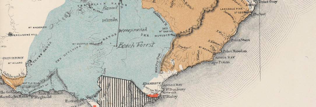
The Cape Otway District Map of 1865
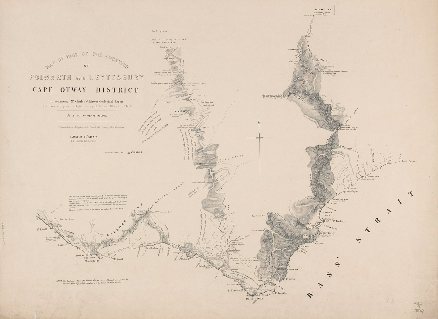
In 1879, when the Cape Otway Forest was declared open for selection, the only maps of the region were compilations of material gathered during mineral survey expeditions, most importantly those undertaken by Charles Wilkinson in 1864[3] and Ferdinand Krausé in 1874.[4] The Aboriginal people of the region had been killed or dispersed in the 1840s, and their tracks had been quickly overgrown; not even their place names remained.[5] The centre of the government’s official Polwarth County map, in fact, was completely blank.
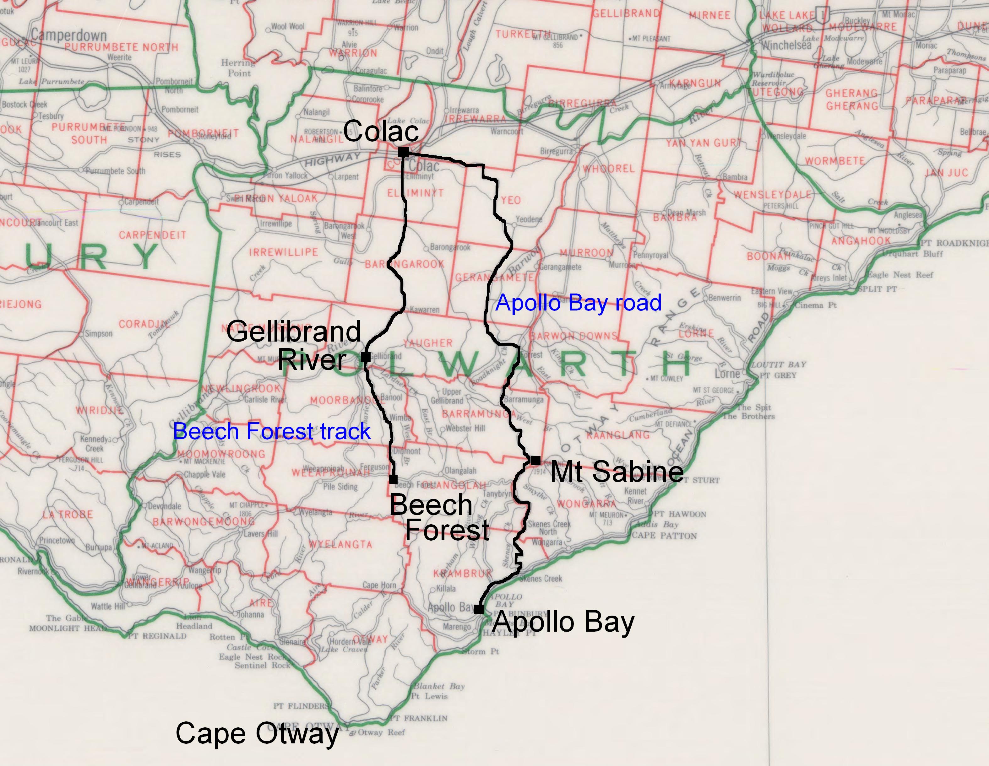
The map did, however, show a track from Apollo Bay at the coast to the top of the range at Mount Sabine, reaching inland towards Colac. Despite its dotted line appearance, the Apollo Bay road was so well marked and used by 1880 that its ‘almost impassable condition’ was a constant source of irritation to the Colac Shire Council, not to mention to the travellers who had ‘to wade up to their knees in mud and slush’.[6] The earliest Otway selectors took up land adjacent to this track.
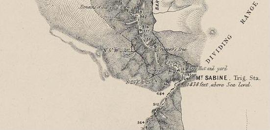
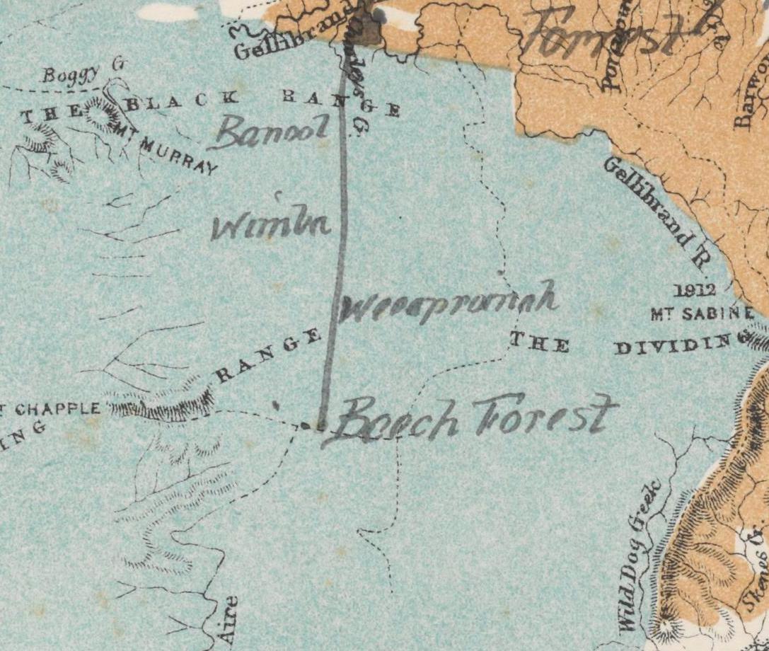
To the west of Mount Sabine, in the central area becoming known as ‘the beech forest’ (from the stands of myrtle beech which grew in the gullies), there were no roads at all. The only track that had been built there since the time of Aboriginal occupation had quickly disappeared under dense forest regrowth.[7] But in February 1883 the colony’s need for timber to shore up its mine shafts and underpin its railways prompted the Colac Shire Council to arrange for its engineer to guide about thirty-five men on ‘A trip to the Otway Ranges’ to inspect ‘the grandeur and magnificence of the timber in the region’.[8] Their reports resulted in a new track survey being undertaken, this time for a railway from Colac to the top of the range to tap the vast timber resources.
The railway survey began in July 1883, and the blazed survey line alone was enough to attract selectors. Within a few months the route was dotted with claims pegged under the 1869 Land Act, clinging to the path of the survey like shipwrecked sailors. Those who didn’t cling were washed away; six men who set out looking for land to select ended up ‘desperately hungry’ at Cape Otway, with ‘worn and haggard appearance’, after being lost in the bush. ‘For three days they scrambled through the thick undergrowth, with no other food than the berries of the native olive and such leaves as they could eat. The rain was falling the whole time, and keeping them soaked to the skin.’[9]
Once the impossibility of building a broad gauge line became evident, the railway survey ended at the 19-mile mark from Colac,[10] but the track was then extended to 26 miles (42 kilometres) by a local surveyor, ending where the township of Beech Forest later developed.[11] With the new Land Act due to divide the Otways into large pastoral holdings in January 1885, in late 1884 there was a rush of smaller selections along the length of the track from the Gellibrand River to the rich land at the top of the ridge.
Virtually all of the Otway selectors under the 1869 Land Act pegged out land fronting onto either the Apollo Bay road or the Beech Forest track, because without a marked and cleared path the forest was impenetrable.
Malcolm Taylor’s List-Map
The selections along the track to the beech forest in 1884 created a substantial problem for the Lands Department. There were no maps and no survey data for the area, and not enough staff surveyors to produce what was required quickly. As the Colac herald pointed out in January 1885, ‘in the absence of a proper plan of its situation, the land officer is unable to deal with the applications that have been lodged’.[12] Everyone had to wait until arrangements could be made with contract surveyors to send a survey party in. The first survey party entered the forest in about April 1885,[13] but it was not until August 1885 – at least eight months after the applications were made – that Richard Birch and Thomas Fender undertook the first allotment surveys in the beech forest.[14] In the meantime, the department asked selectors to provide their own sketch of the location of the land they were applying for. Many who knew the layout of the country had no difficulty in doing so, and some, like William Raper who lived along the Gellibrand River, could tell the department more than its own staff knew. He sketched the upper branches of both Lardners Creek and Charleys Creek, including the spurs leading off the railway survey as well as the main range.
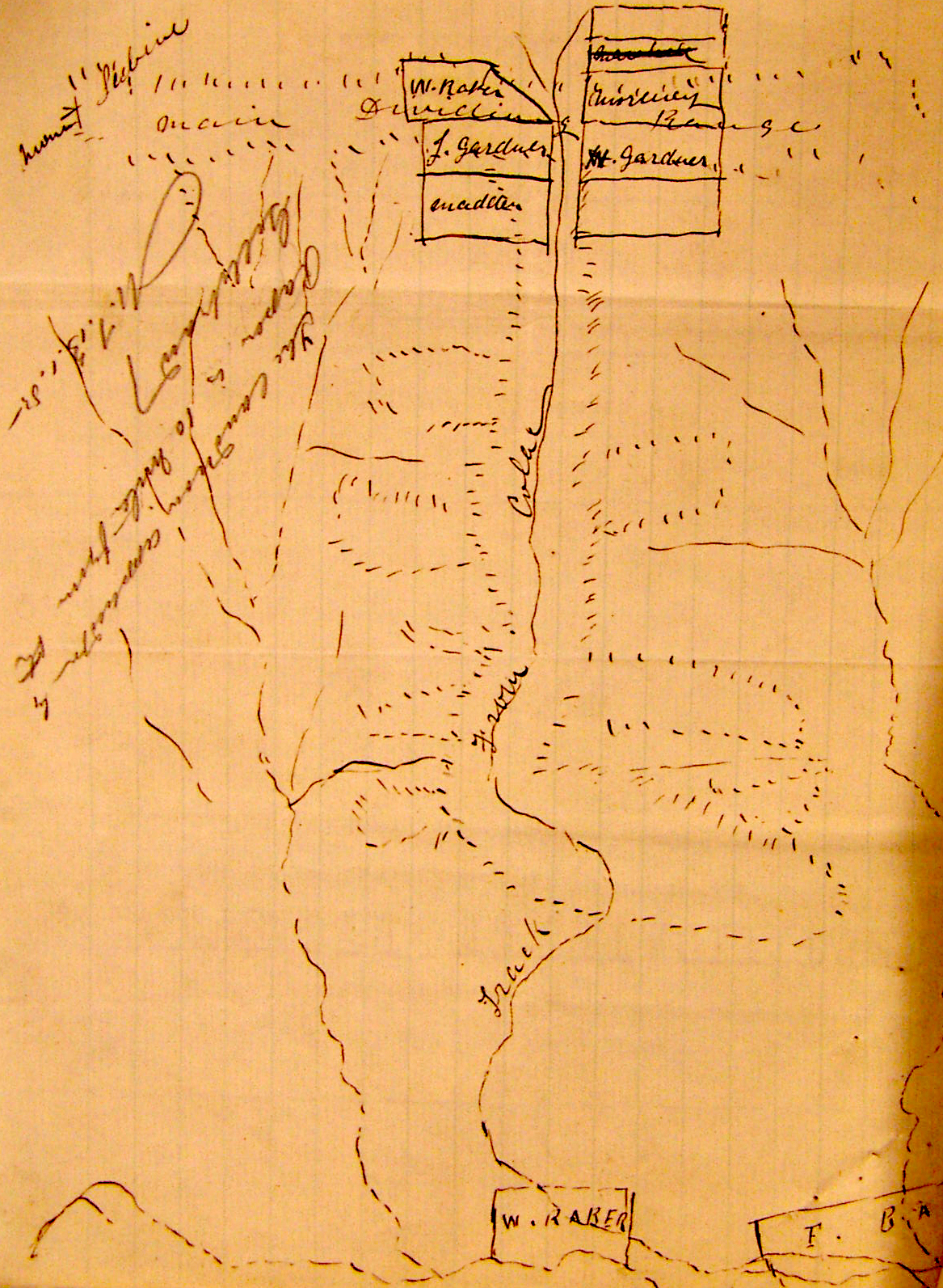
There were others, though, such as James Hills, a Colac butcher, who took exception to the request. ‘I have always thought’, he replied, ‘that it was the duty of the Surveyor, and what he is paid for to supply that information’.[15] Hills said he couldn’t supply it, and asked for a refund of his application fee. The Land Officer in Geelong (Malcolm Taylor) replied that he was unable to refund the money, nor could he proceed with the application without a sketch. Presumably in order to overcome such stalemates, a master sketch of the area was made in the Geelong office, and Taylor used it to keep at least a notional record of which land had been selected and by whom. As the applications were processed, tracings were sent to applicants with the request that they mark their selection on the tracing and return it to the Land Office. Hills was somewhat surprised to receive one since he thought he had withdrawn his application, but he marked his selection and sent it back anyway.
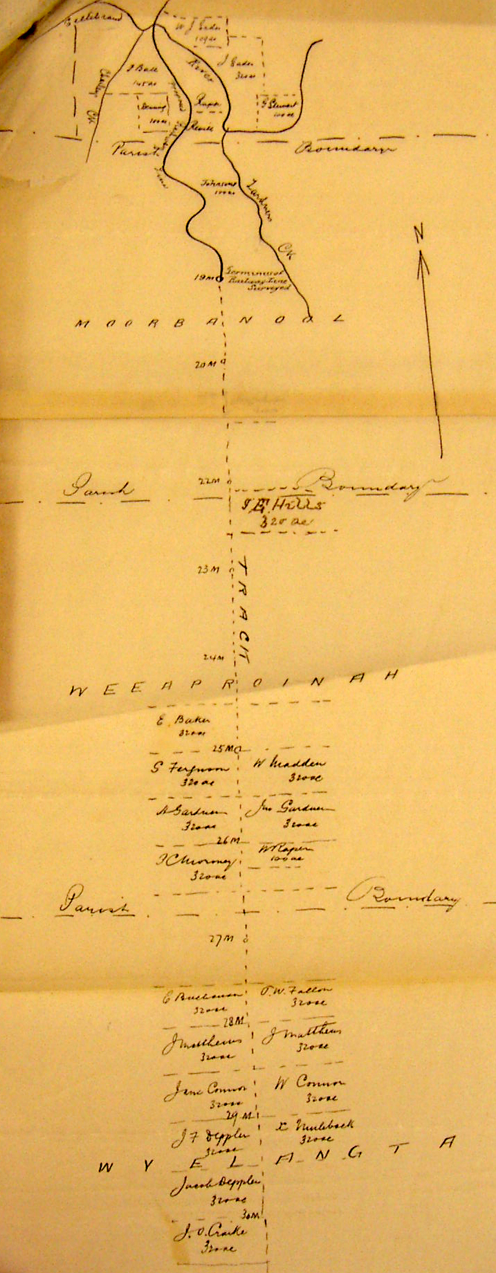
At the time this tracing was made (early 1885, prior to surveyors entering the forest), even the location of the parish boundaries was uncertain. South of the ‘Terminus of Railway Line Surveyed’ the tracing was more of a list than a map, but without proper surveys it was the best spatial representation the Lands Department had.
Fortunately, after the rush in December 1884, applications ceased for about six months because the new Land Act came into force on 1 January 1885 and the Otway map was not published until June. For selectors under the Land Act 1869 Taylor’s list-map was adequate for its purpose. The selectors had chosen and pegged the land they wanted; they just had to wait for the Lands Department to survey it. The arrival of the Land Act 1884, however, threw their plans into disarray.
The First Land Act 1884 Selection Map: Pastoral
When Albert Tucker, Commissioner of Crown Lands, introduced the new Land Bill to the Legislative Assembly in July 1884, he explained that free selection before survey was causing a number of difficulties. Selectors, he said, had begun ‘to take up small patches of land here and there, following the course of valleys, so that … it is no uncommon thing to find one selector having five or six, or even more, selections’. This cherry-picking, he said, tended to ‘throw a large area of country out of occupation altogether’, since the remaining land was likely to be less useable.[16] The new Act, therefore, would place the control of selection boundaries in the hands of the government; selectors would be required to take the land as surveyed, and only hold one selection per person. The land would also be classified according to its capabilities, and the terms of selection would vary according to the classification.
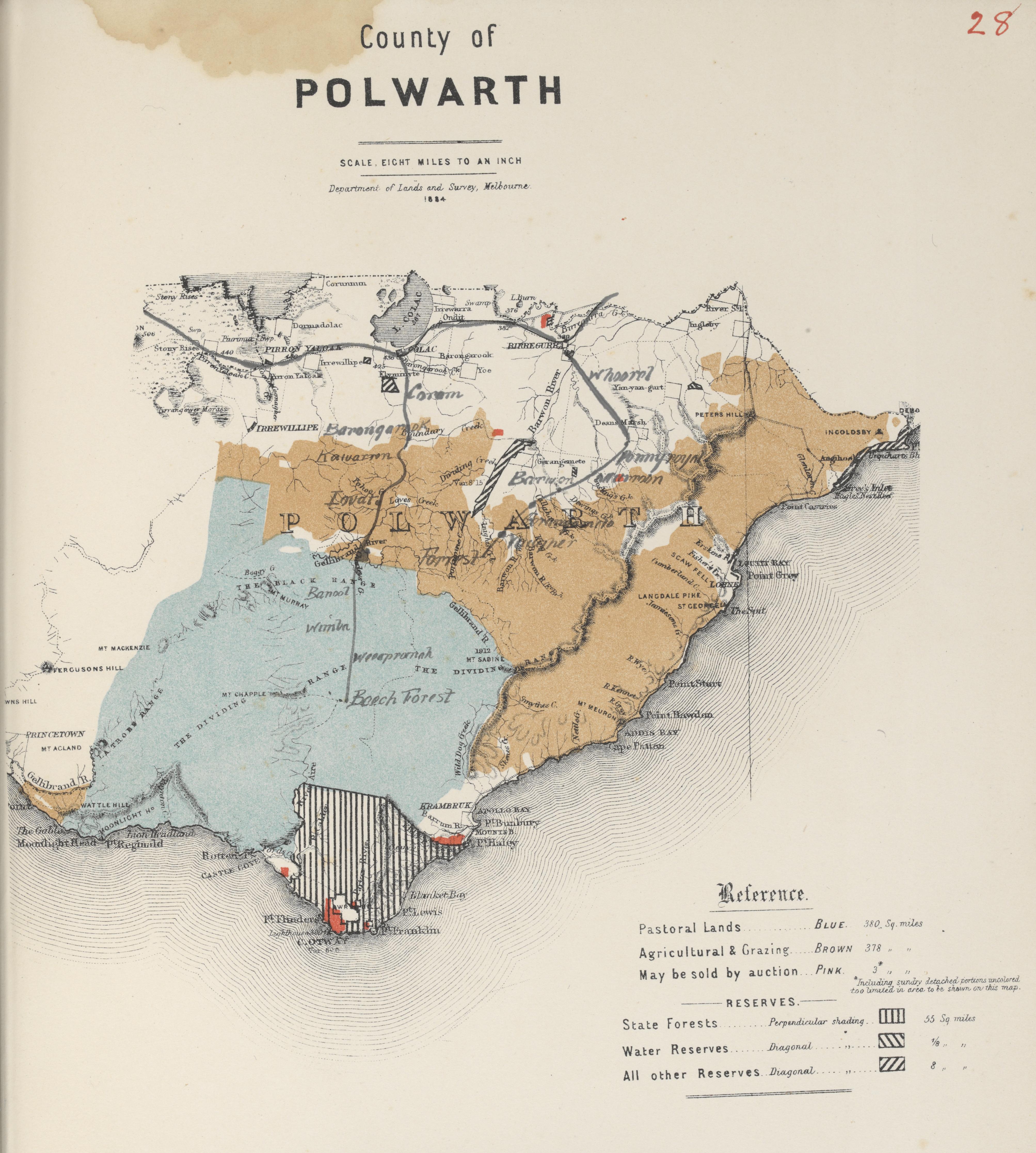
Under the Land Act 1884, selection was to be made from maps prepared by the Survey Branch of the Lands Department, the first series of which gave only the broad classification of the land. The Polwarth County map of this series shows the Cape Otway forest as an undifferentiated area of country tinted blue, suitable for pastoral use only. The southern tip of Cape Otway was marked to remain as state forest, and some small areas (marked in pink) were to be sold at public auction.
The almost bare map shows a series of dotted lines representing tracks running across the centre of the forest, despite the fact that none of these routes were considered useable even as pack tracks at the time.
Apart from the largely imaginary tracks, the major problem with this map was that it did not show any of the selections that had already been pegged under Land Act 1869.
The Second Land Act 1884 Selection Map
The selection map of the County of Polwarth that showed previous selections was not published until five months after the Land Act 1884 came into effect (on 1 June 1885).[17] When it finally appeared the map showed the land that was to be made available in pastoral allotments coloured ‘blue’, divided up and labelled A-L. It also showed a strip of brown and white agricultural allotments running north-south through the pastoral blue. The outlines of Selwyn’s etched map can be seen beneath the colouring, with the addition of some hills (known as ‘the Barrier range’) running in an arc around the north and west of the central forest, which is still blank.
At the time this map was published, surveys of the allotments selected under the Land Act 1869 had not yet begun, and while Thomas Fender (the contract surveyor responsible for the area) reported in October that ‘we will be finished in two or three weeks weather permitting’,[18] the survey data was not fully plotted until February 1886.[19] Drawing a selection map under these circumstances was difficult, but the Act required the Lands Department staff to do so. The draftsmen appear to have solved the problem by taking Malcolm Taylor’s working list-map and overlaying it on the map of the County of Polwarth. The application areas are shown in white, but the layout, allotment numbers and acreages were drawn entirely without reference to the ground. Since the Land Act 1869 selectors had mostly climbed the hills and dodged the giant trees to peg their selections, they must have been astonished by the pattern of straight lines.
Amendments to the Second Land Act 1884 Selection Map
By the time this second selection map was published, it was widely known that there was good land to be found in the beech forest, and pressure was building to re-classify it as Agricultural and Grazing land. In August 1885 the Surveyor-General recommended that Pastoral Allotment F be made available for selection and the minister agreed; accordingly, it was ‘coloured brown’ on the map, and the process of subdivision was set in motion.[20]
In his report of 14 October 1885, however, Thomas Fender pointed out that Pastoral Allotment F was ‘considerably out of position on the new maps’, and suggested that the proposal to offer more land for selection be kept in abeyance until his surveys were completed, at which time he could then offer advice on what country would be most suitable.[21] The Surveyor-General concurred and the subdivision was set aside to wait for the completed surveys.
The earlier map was still in circulation, however, and intending selectors continued to use it to ‘locate’ the land they wished to select, and to pressure the minister to make more land available. Even as late as 15 March 1886, when William Green requested ‘the land coloured blue on the attached tracing’ to be made available, it is clear that the drawing was derived from Taylor’s list-map, not survey data.[22]
Pastoral Classification versus Agricultural and Grazing
None of the tracks dotted on these early selection maps were navigable by other than foot traffic, but still a few intrepid opportunists took up the challenge and applied for the pastoral leases delineated by the lines on the second selection map. They included Alexander Wallis, the former secretary of the Department of Agriculture who, along with District Surveyor Callanan, had provided the report which resulted in the opening of the Cape Otway Forest for selection in 1879.[23] Wallis applied for his run, Pastoral Allotment E of 25,000 acres (over 10,000 hectares), on 31 October 1885,[24] several weeks after Thomas Fender pointed out that Pastoral Allotment F was ‘considerably out of position’. It should have rung alarm bells for the Lands Department, and prevented the approval of any more applications for pastoral leases (including Wallis’s) but it didn’t. Instead, the department gave itself a safety margin by reducing his proposed lease to 15,500 acres (about 6,300 hectares),[25] and went on with the usual administrative processes for issuing leases of this kind. And there the matter rested, until January 1886, when Wallis became impatient with the delay in issuing his lease and pushed for some action.[26] The delay, of course, was due to the lack of survey data for determining the boundaries of Wallis’s pastoral leasehold, and when all the pieces of the beech forest jigsaw were finally assembled the department found that the Land Act 1869 residential applications encroached substantially on Wallis’s holding. The red hatched shape below and to the left of the large red ‘A’ on the map (image below) shows the location of these selections as plotted in February 1886.
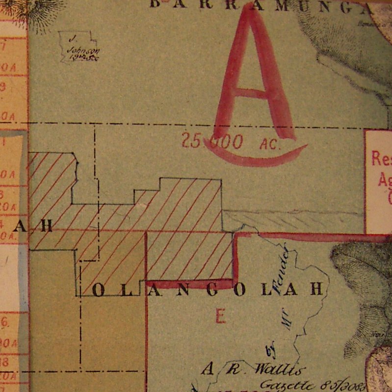
A large part of the problem was the track. On Malcolm Taylor’s list-map it was a straight line, north-south, from the Gellibrand River to the beech forest. In the selectors’ minds, no matter which way they faced or where the track went, it was the frontage for their blocks. But on Thomas Fender’s survey it was a line cutting crookedly through Wallis’s Pastoral Allotment E. Putting everyone’s expectations together, the map had let the selectors down badly: the department had effectively leased the same land twice.
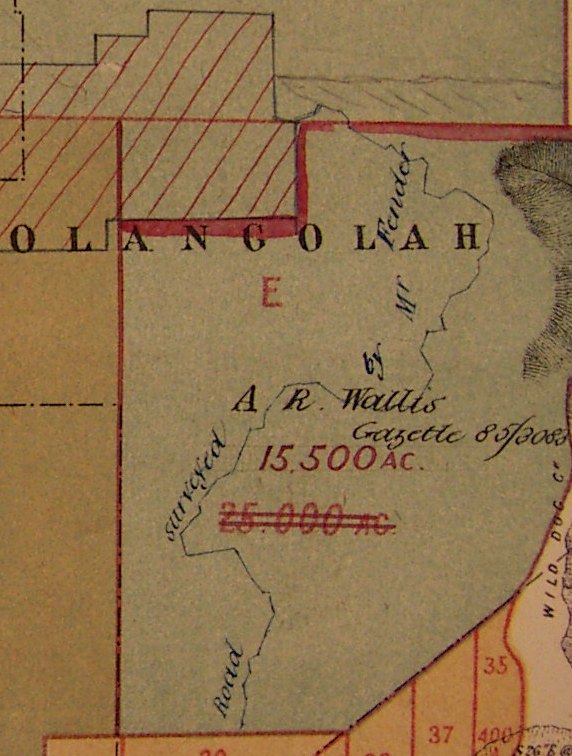
The first solution the Lands Department came up with was the simplest: take the land promised to the selectors out of Wallis’s lease, and give him an equivalent area from another pastoral allotment.[27] Wallis agreed to that, but when the draftsmen finished plotting Fender’s surveys, and he was finally able to fulfil his promise to indicate which country he considered suitable for selection, his recommendation threw everything up in the air again.
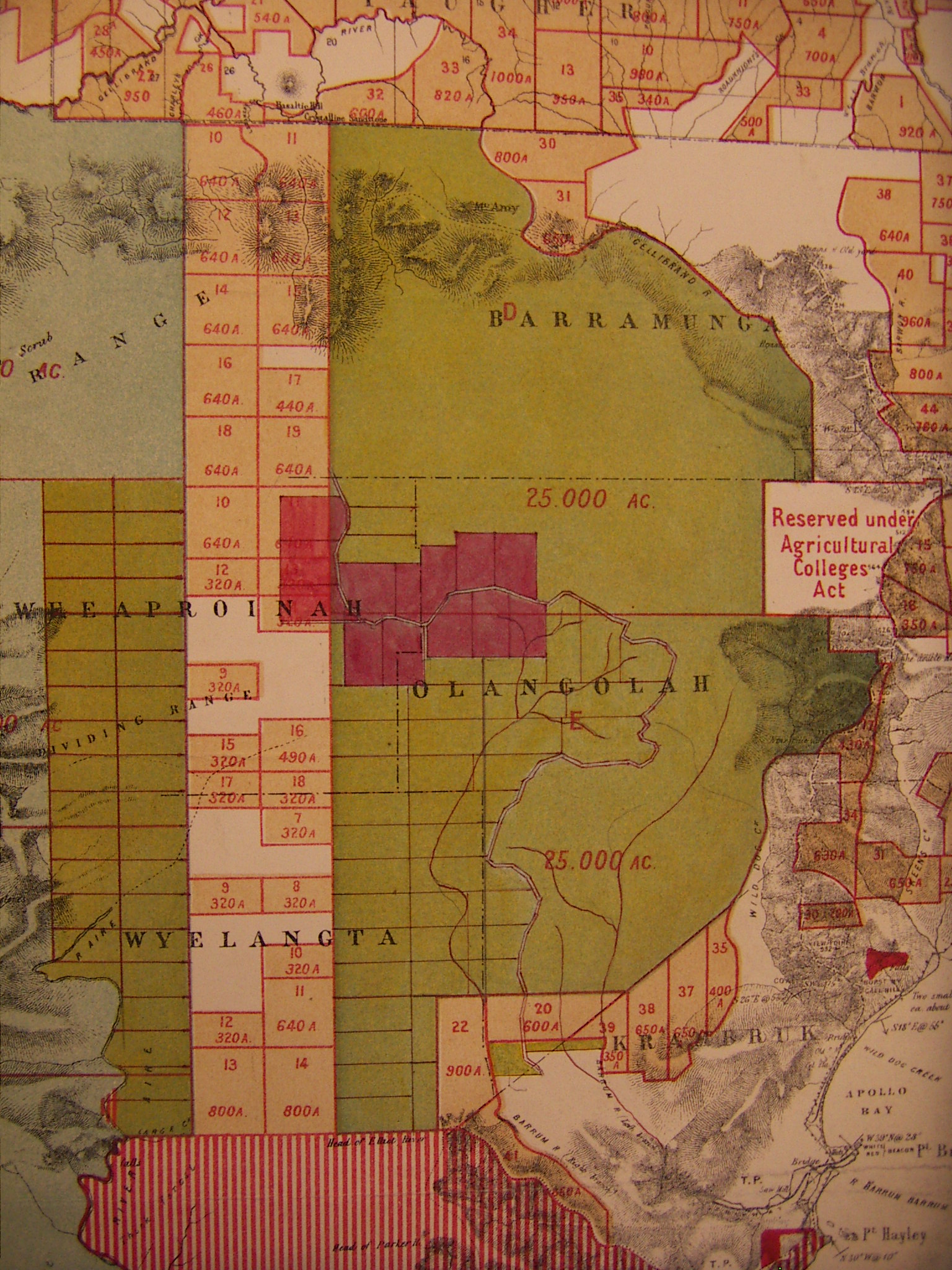
Fender recommended that all of the area tinted ‘yellow’ (see image above) should be offered for selection under Part III (Agricultural and Grazing Allotments) of the Land Act 1884.[28] That meant Wallis’s entire pastoral lease, not only the part taken by the Land Act 1869 selectors. Not surprisingly, Wallis was unimpressed and he drove a hard bargain in return for relinquishing his pastoral lease. The government offered him compensation of a single pre-emptive Homestead allotment of 320 acres (130 hectares), but instead he demanded four allotments.[29] Eventually the minister agreed to his demand, and Wallis was asked to choose four blocks.[30]
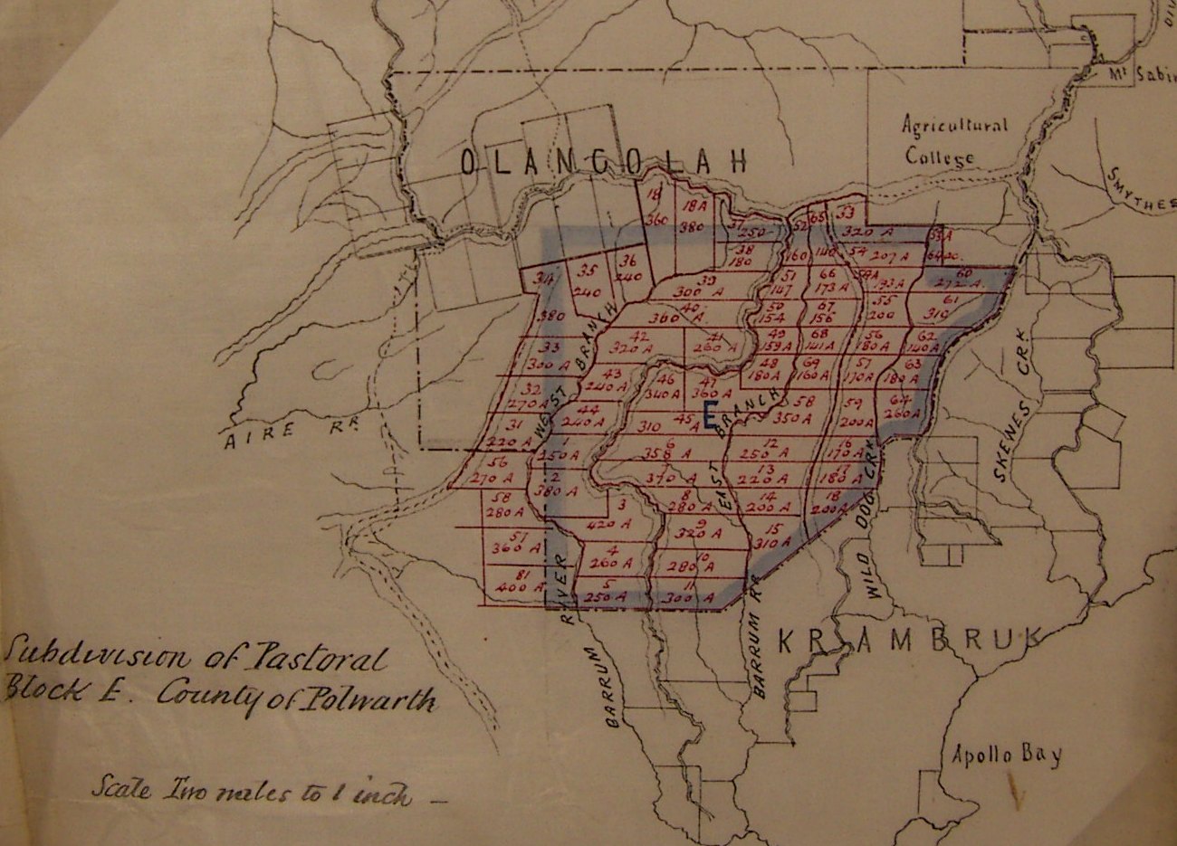
The Third Land Act 1884 Selection Map
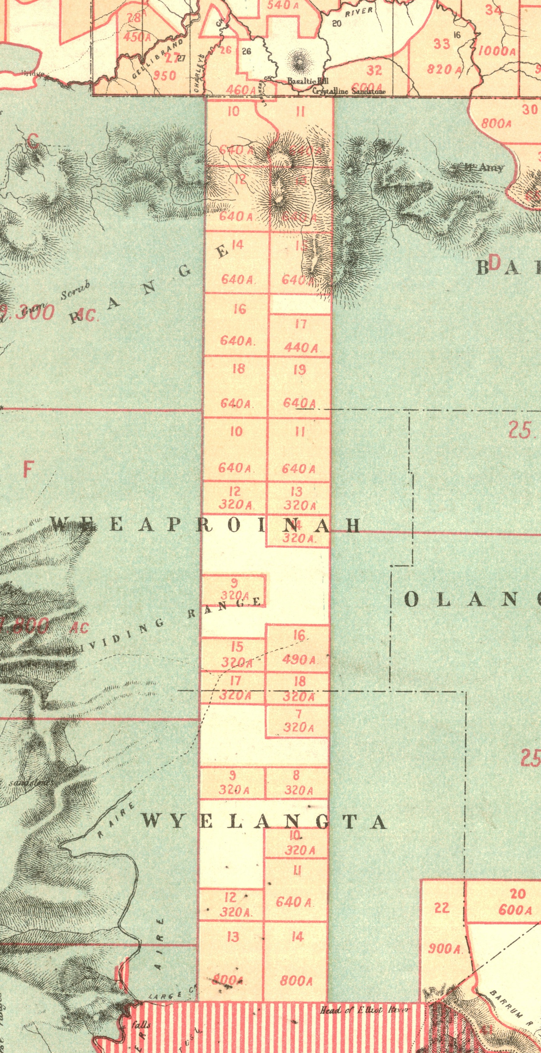
District Surveyor Callanan supplied a design for subdividing Pastoral Block E into Agricultural allotments[31] in accordance with Fender’s earlier advice – ‘I do not think large areas of any use in such heavily timbered country and the lots should [not] exceed 300 or 320 acres’ (130 hectares)[32] – and Wallis chose allotments 18A, 37, 38 and 39.
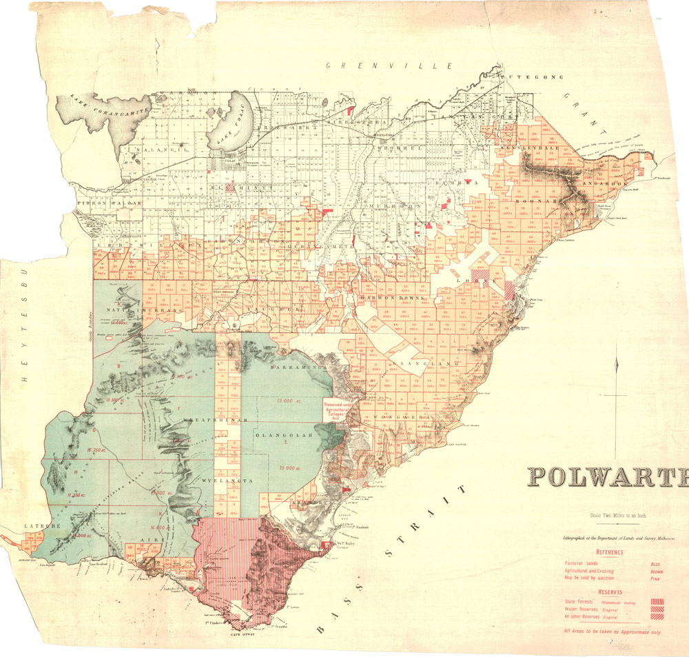
Under instruction from the Minister of Lands,[33] who was under pressure to open the Otways for agricultural selection, the department then published the third selection map of ‘Supplementary Grazing & Pastoral Areas’ (see image below),[34] and opened the area for selection on 17 November 1886 under the Land Act 1884.[35] Based on minimal survey data, the whole of the parishes of Weeaproinah, Barramunga, Wyelangta and Olangolah were opened for agricultural selection, together with parts of Aire, Krambruk and Barwongemoong.[36] Despite Callanan’s advice on his survey design that ‘we cannot pretend to give complete accuracy of the features’,[37] his map was reproduced for the use of intending selectors with few alterations other than the insertion of a ‘Township reserve’. The map showed an extraordinary array of straight lines across what turned out to be exceedingly rough terrain. The Argus scathingly dismissed it – not unreasonably – as ‘having been merely cut into blocks with rulers in the Lands department’.[38]
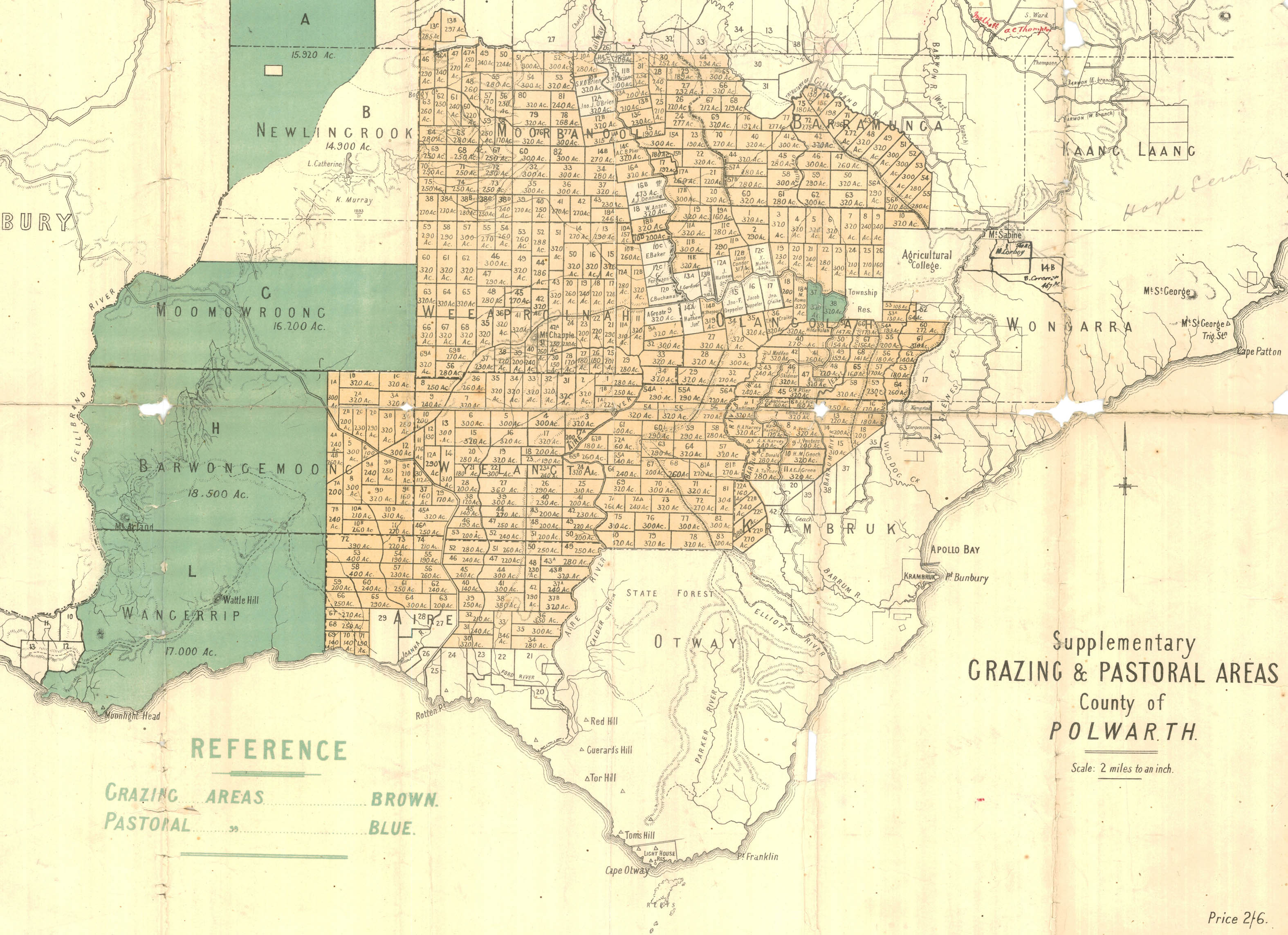
The Lands Department produced the straight lines knowing that they were notional, but having sorted out the overlap problems with the Land Act 1869 selections, and knowing that selectors under Land Act 1884 could not move onto their recommended allotments until they had been properly surveyed, they might have expected clear sailing ahead. The map method, however, fundamentally changed the process of selection and led to some unexpected difficulties, which in turn led to widespread failure for the selectors.
The Survey Process
To begin with, the inaccessible nature of the Otway country meant that the selectors, who chose their land from a map rather than pegging it, were unable to check their selection before applying for it. They were also often unable to locate it after it was recommended to them. Patrick Davey, for example, went to the forest with the Local Land Board’s recommendation but ‘could not find it there is no guide in that [locali]ty to show me anything [of] it I had no tracing map to show or instruct me’.[39] Almost a year later, he reported:
I wrote to the Age newspaper that Journal directed me by way of Appollo Bay [sic] I went by that direction but was unsuccessful I then wrote to the Land Office at Geelong and got the latest map and tracing with directions regarding route Via Colac, Camperdown Cobden and Princetown and then after that the Lord Knows where… I advertised for a guide and would give £10 but got no response.[40]
Davey finally admitted on 5 June 1895: ‘I never could find it’.[41] His land was forfeited. Part of the problem was that allotments were numbered by parish, but the parish boundaries had not been set.[42]
For those selectors who did manage to find their allotment, the next problem was the ground itself. As Thomas Blacker explained in 1889, ‘after inspection I find that the land is extremely rough and in no part is there a suitable spot to build the land being nothing but a steep gorge’.[43] Selectors frequently found their land to be as Daniel Vaughan described it, ‘fairly standing on its end’.[44] For the lucky ones who both located their land and found it useable, access then became an issue. Selecting land from a map meant that selectors were dotted over the ranges like a chequerboard, and it was impossible for authorities to build roads quickly enough to service them all. Many, like James Grant Cooke, decided not to wait but to build their own, but when Cooke informed the department that ‘there is no track for 14 miles except the one that several of us have paid to have cleared & this is not fit for a horse to travel on’,[45] he found that the money he expended on making the failed track did not count as ‘improvements’ under the Act. He, too, forfeited his land.[46]
For those who managed to find their land and settle on it, there was another hazard that arose from the maps, and that was the mismatch between the selection map and the official survey pegs. On their application forms the earliest selectors specified their land in relation to the mile pegs to the beech forest, but the forms required them to give the number of the allotment as shown on the Land Act map. Unfortunately, the map had no mile pegs drawn in, so that selectors and the Land Officer alike had to guess at the correlation between the allotment numbers and the pegs. This led to selectors like John Graham, for example, choosing the land they wanted and specifying it by the mile pegs, only to have the wrong allotment number put on their recommendation. Sometimes a simple explanation from the surveyor could sort these matters out,[47] and sometimes the surveyors could simply adjust the areas given to each selector.[48] But in John Graham’s case the mess only became apparent when the surveyors began marking his block some distance away from where he had already built his house – on an allotment recommended to someone else.[49]
‘Mr Graham’, said surveyor Fender’s bald reply to the department’s request for an explanation, ‘is not on the land recommended to him by the [Local Land Board], I am effecting survey according to instructions’.[50] The instructions, of course, were set on the basis of the allotment numbers on the Land Selection map, which made no reference to mile pegs at all.
Fortunately for Graham and the Lands Department, the man who had been recommended the allotment where Graham had built his house had not paid his survey fees, which allowed the department to forfeit his rights to the block and resurvey it for Graham and his neighbour, who was in a similar predicament.[51] This sort of shuffle went on for years as the surveyors struggled to fit the selectors’ choices to the map, and adjust the map to fit the ground; hundreds of selectors had forfeited by the time the next selection map was published in 1893.[52]
The Land Act 1890 Selection Map
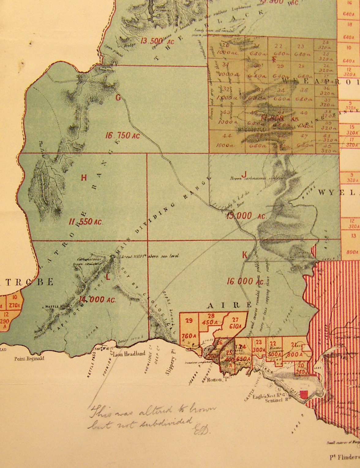
Under the Land Act 1890 a new map showing the land available for selection (and the land already taken) was produced.
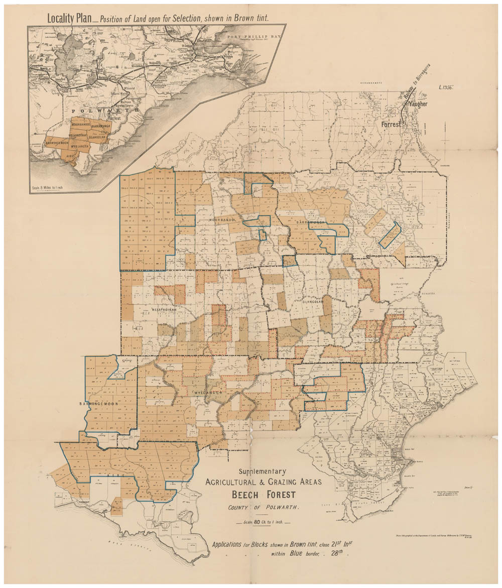
This 1893 map, at least, showed some surveyed roads and gave a more accurate idea of some of the river courses, although Fénélon Mott (one of the contract surveyors) pointed out a few months after the map was published that ‘the Joanna [River] is not shown at all correctly’.[53] In the same memo Mott also advised the Lands Department that his work would ‘materially alter the design of the Beech Forest map’, but so did the work of many other surveyors of the time. One surveyor ‘found the Carlisle Creek was much more into allot 58 than shown on tracing’,[54] and Mott also observed that ‘a road running NW as shewn on plan is impossible’.[55] Seven years after the first selectors were given permission to occupy, the beech forest selection map was still a work in progress, and it provided no reliable guide to the terrain. Eventually the solution was to redo the survey design of several sections, including part of the parish of Aire (which Mott referred to), the south-western corner of the parish of Weeaproinah – where ‘the country all falls away rapidly to the west’[56] – and a central part of the parish of Wyelangta.[57] Such wholesale re-design of survey layouts was only made possible by the failure of the selectors who had taken up the land first and suffered heavily from difficult conditions and poor access to their blocks. About three-quarters of the early selectors left without obtaining their Crown grants.[58] By abandoning or forfeiting their selections they left the way open for better surveys and maps for the next round of selectors.
The Legacy of the Maps
Under the Land Act 1869, when selectors had to peg their selections themselves, the Otway forest remained virtually untouched. Selectors avoided the heavily timbered rich soil on top of the main ridge and clung to the few existing tracks. Under the Land Act 1884, however, when selectors chose their blocks from numbered allotments on a map, the entire forest was snapped up in eight days of Local Land Board sittings. Hundreds of selectors pinned the tail on the donkey and took up inaccessible land they had never seen.
The land selection maps of the Otways were not merely administrative aids; they were active agents in constituting the idea of settlement. The 1886 selection map ‘Supplementary Grazing & Pastoral Areas’ was the key to the government’s offering of a vast tract of rough, densely timbered forest country for grazing leases. The rivers and ranges were in the wrong places and most of the sectional roads were non-existent, but it made the forest look like a suburban subdivision – straight line boundaries, frontage to water sources neatly allocated, and service roads strategically provided. The distribution of patches of white land that had already been selected, too, seemed to indicate clusters of settlement – civilisation – in the centre of the forest and on the south coast. The map created the possibility of ‘smiling homesteads’ bringing forth ‘the fruits of the earth in great abundance’.[59] As JB Harley has pointed out, however, ‘maps are slippery customers’.[60] The Lands Department produced the Otway maps to the best of its ability from limited information,[61] but the selectors read them through rose-coloured glasses. Selectors, legislators and administrators alike were ensnared by the image of the yeoman farmer happily settled on his block, but in the Otways, as everywhere else in Australia, the image bore little resemblance to reality. Failure took different shapes in different places; in the Otways it can be seen first of all in the straight lines on the maps.
Endnotes
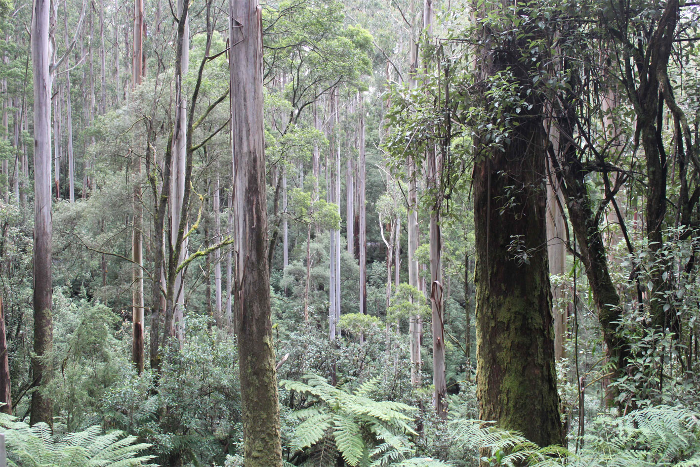
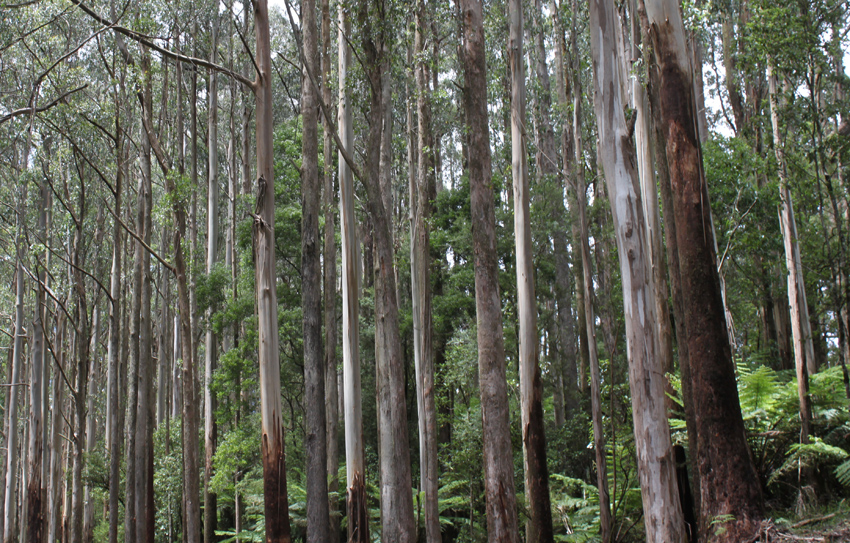
[1] For background and detailed information on Victoria’s Acts, see P Nelson and L Alves, Lands guide: a guide to finding records of crown land at Public Record Office Victoria, PROV, North Melbourne, 2009. All photographs of forest landscapes that appear in this article without captions are from the author’s personal collection.
[2] The best overall summary of land selection in Victoria remains JM Powell, The public lands of Australia Felix: settlement and land appraisal in Victoria 1834-91 with special reference to the Western Plains, Oxford University Press, Melbourne, 1970. Powell examined in detail the debates leading up to the Acts of the 1880s, but his study closed without assessing their results.
[3] CS Wilkinson, ‘Report. To the Director of the Geological Survey, Melbourne’, Victorian parliamentary papers, Session 1864-65, vol. 4, 1864, no. 44, pp. [21]-8.
[4] FM Krausé, ‘Report on the Cape Otway District, 1 August 1873’, in Geological Survey of Victoria: report of progress, ed. R Brough Smyth, Government Printer, Melbourne, 1874, Appendix A, pp. 99-109; FM Krausé, Geological sketch map of the Cape Otway District, Mines Department, Coal Fields Board, Melbourne, 1874.
[5] L Niewojt, ‘The massacre of the Gadubanud at Aire River’, Victorian historical journal, vol. 81, no. 2, 2010, pp. 193-213. Aboriginal parish names are not from local languages.
[6] ‘The Apollo Bay track’, Colac herald, 15 June 1880.
[7] Letter from WH Short to JH Connor, 7 June 1876, in JH Connor Papers 1866-1996, Australian Manuscripts Collection, State Library of Victoria, PA96/62.
[8] ‘Report on Colac Forrest [sic]’, Colac herald, 19 December 1882; ‘A trip to the Otway Ranges’, Colac herald, 13 February 1883; ‘The Cape Otway beech forest’, Colac herald, 23 February 1883.
[9] ‘Lost in the Otway Ranges’, Colac observer, 2 April 1884.
[10] ‘The forest survey’, Colac observer, 19 March 1884; PROV, VA 538 Department of Crown Lands and Survey, VPRS 5357/P0 Land Selection and Correspondence Files, Unit 5587, File 1666/42.44, JE Johnson’s sketch [1884].
[11] PROV, VA 538 Department of Crown Lands and Survey, VPRS 626/P0 Land Selection Files by District, Unit 948, File 1703/19.20, memo M Taylor to D[istrict] S[urveyor], 4 December 1884.
[12] Colac herald, 30 January 1885.
[13] ‘Bridge over the Gellibrand’, Colac herald, 17 April 1885.
[14] PROV, VPRS 626/P0, Unit 948, File 1703/19.20, survey data for John Gardner’s block; Colac herald, 17 July 1885.
[15] PROV, VPRS 626/P0, Unit 950, File 1811/19, letter from James Hills, 6 January 1885.
[16] Victoria. Parliamentary debates, vol. 45, Session 1884, p. 497.
[17] Colac herald, 26 May 1885. The Polwarth map was never announced in the Victoria Government gazette as being available for purchase. Copy in PROV Historic Maps Collection, VPRS 15899/P1, LC 28.
[18] PROV, VPRS 5357/P0, Unit 205, File 1910/21.29, memo T Fender to M Taylor, 14 October 1885.
[19] ibid., memo M Taylor to J Thomas, 16 February 1886.
[20] ibid., letter AJ Skene, 20 August 1885, countersigned ALT[ucker, Minister of Lands], 21 August 1885.
[21] ibid., memo T Fender to M Taylor, 14 October 1885.
[22] PROV, VPRS 626/P0, Unit 948, File 1703/19.20; see also Unit 955, File 2139/19.20, letter and sketch Stephen Venters, 15 March 1886.
[23] ‘Cape Otway State Forest’, Colac herald, 11 February 1879.
[24] PROV, VPRS 5357/P0, Unit 205, File 1910/21.29, lease application AR Wallis.
[25] See details for revised Pastoral Allotment E in the image directly following the next paragraph in the text, with the caption Fragment Land Act 1884 Selection map, No 2, 1 June 1885, amended by Joseph Thomas (detail 2).
[26] PROV, VPRS 5357/P0, Unit 205, File 1910/21.29, letter from AR Wallis, 28 January 1886.
[27] ibid., memo N Wimble to Surveyor General, 23 February 1886.
[28] ibid., memo T Fender to M Taylor, 15 March 1886.
[29] ibid., letter from AR Wallis, 14 July 1886.
[30] ibid., memo ‘JLD’ to Mr Morrah, 3 September 1886.
[31] ibid., memo M Callanan to JA Levey, 10 September 1886.
[32] ibid., memo T Fender to M Taylor, 15 March 1886.
[33] ibid., file note ‘JLD 8.4.1886’.
[34] Polwarth Map G20, Geelong Heritage Centre; folded copy at PROV, VPRS 5357/P0, Unit 292, File 5451/47.
[35] Victoria Government gazette, no. 124, 19 November 1886, p. 3227.
[36] ibid., and Victoria Government gazette, no. 126, 26 November 1886, p. 3289.
[37] PROV, VPRS 5357/P0, Unit 205, File 1910/21.29, memo M Callanan to JA Levey, 10 September 1886.
[38] The Argus, 17 January 1887, p. 4f.
[39] PROV, VPRS 5357/P0, Unit 242, File 152/35, letter from P Davey, 16 April 1891.
[40] ibid., February 1892.
[41] ibid., 5 June 1895.
[42] PROV, VA 538 Department of Crown Lands and Survey, VPRS 440/P0 Land Selection and Occupation Files, Unit 1209, File 1977/32, letter from Thomas Widdicombe, 17 January 1887; PROV, VPRS 440/P0, Unit 1208A, File 1509/32, letter from John Keane, 8 December 1886.
[43] PROV, VPRS 440/P0, Unit 1205, File 0121/32, letter from T Blacker, [1889].
[44] PROV, VPRS 440/P0, Unit 1217, File 3878/32, letter from D Vaughan, 3 March 1896.
[45] PROV, VPRS 440/P0, Unit 1206, File 343/32, letter from JG Cooke, 23 April 1891.
[46] ibid., 3 February 1893.
[47] PROV, VPRS 5357/P0, Unit 5839, File 2399/50.51, memo T Fender, 4 January 1888.
[48] PROV, VPRS 5357/P0, Unit 5820, File 5322/47.98.49, memo Fender & Short to M Taylor, 10 May 1888.
[49] PROV, VPRS 5357/P0, Unit 233, File 677/42.44, letter from J Graham, 13 July 1886.
[50] ibid., file note T Fender, 17 July 1886.
[51] PROV, VPRS 440/P0, Unit 1209, File 1901/32, William Webster forfeiture, 23 July 1886.
[52] B Minchinton, ‘“That place”: nineteenth century land selection in the Otways, Victoria, Australia’, PhD thesis, University of Melbourne, 2011, table A4.1.
[53] PROV, VPRS 5357/P0, Unit 4556, File 3012/MISC, memo Mott to Land Officer, 11 August 1893.
[54] PROV, VPRS 5357/P0, Unit 5554, File 2770/49.50, memo James Short to M Taylor, 27 February 1894.
[55] PROV, VPRS 5357/P0, Unit 5547, File 2971/49.50, file note F Mott, 2 November 1893.
[56] PROV, VPRS 5357/P0, Unit 5869, File 438/46, memo J Short, 24 November 1897.
[57] PROV, VPRS 5357/P0, Unit 350, File 1520/42, memo JM Reed, 18 December 1894.
[58] Minchinton, ‘“That place”’, table A4.7.
[59] Colac herald, 14 January 1879.
[60] JB Harley, ‘Deconstructing the map’, in TJ Barnes and JS Duncan (eds), Writing worlds: discourse, text and metaphor in the representation of landscape, Routledge, London & New York, 1992, p. 239.
[61] For more about the Lands Department’s involvement in Otway selection, see Minchinton, ‘“That place”’, especially pp. 277-317.
Material in the Public Record Office Victoria archival collection contains words and descriptions that reflect attitudes and government policies at different times which may be insensitive and upsetting
Aboriginal and Torres Strait Islander Peoples should be aware the collection and website may contain images, voices and names of deceased persons.
PROV provides advice to researchers wishing to access, publish or re-use records about Aboriginal Peoples