Last updated:
‘Common to all miners: the Inglewood Gold Field Common’, Provenance: The Journal of Public Record Office Victoria, issue no. 16, 2018. ISSN 1832-2522. Copyright © Peter Davies, Karen Twigg & Susan Lawrence.
This is a peer reviewed article.
Goldfields commons were established in numerous locations in nineteenth-century Victoria. These large parcels of Crown land provided accessible grazing for gold miners and kept land around the goldfields in the public domain. In addition to the 80 or so goldfields commons declared, there were several hundred town and farmers' commons as well, covering in total more than 1 million acres of the Victorian countryside. The Inglewood Gold Field Common was broadly typical of this wider pattern. Established in January 1861, it initially encompassed more than 50,000 acres of mallee woodlands, grasslands and auriferous outcrops. Correspondence preserved in Public Record Office Victoria reveals the many ways that miners and local residents utilised the common, and how managers and users tried to negotiate and resolve the problems they encountered. These ranged from complaints by local squatters about loss of their land to claims by selectors, plagues of rabbits and the important role of Chinese market gardeners. The Inglewood Gold Field Common was officially abolished in 1898, but much of the land remains in public hands today.
Introduction
Land appropriation was a defining feature of European settler colonialism in the eighteenth and nineteenth century. Historian John C Weaver has called this the ‘great land rush’ that brought British colonists to the United States, Canada, the Cape Colony in South Africa, Australia and New Zealand.[1] The new arrivals drove off Indigenous inhabitants, seized a billion acres for grazing their flocks and herds and reshaped property rights to satisfy their hunger for land. Open range and common lands were an important part of this process. The commons served as a stepping stone, or intermediate stage, between the assertion of Crown ownership and public domain on the one hand, and private property rights on the other.
In the wake of the gold rush, goldfields commons (GFCs) were established on numerous parcels of public land across Victoria. They were intended to provide pasture and grazing for holders of miner’s rights on the goldfields while maintaining the Crown’s possession of the land. There were more than 80 GFCs established, which typically ranged in size from 1,000 to 10,000 acres—although, occasionally, much larger commons were declared. Town commons and farmers’ commons were established for similar purposes. The commons drew on traditional notions of rights of access to land and its resources that were well known from England. However, in Victoria, the idea was adapted to the unusual social and economic conditions of the time and the rapidly evolving character of rural land tenure.[2] Although, over time, the commons were whittled away, sold off and eventually abolished, much of the land originally reserved around the goldfields remains as public land today.
Geographer JM Powell drew attention to GFCs within the context of historical European settlement and land alienation in nineteenth-century Victoria.[3] Ray Wright later identified how bureaucrats accommodated the commons in relation to land issues and the public interest.[4] In this paper, we draw on the rich archival sources of Public Record Office Victoria (PROV) to examine the Inglewood GFC. The Inglewood case study provides a valuable lens through which to explore the role of commons as a resource for various users, as well as the issues confronted by managers and users of goldfield commons, and how they negotiated responses and solutions. Typical problems included stocking rates, squatters’ complaints, boundary maintenance, selection pressures, weeds, rabbits, mining activity and the role of Chinese market gardeners. The Inglewood GFC operated from 1861 to 1898—a longer time period than most GFCs; nevertheless, the correspondence preserved in PROV sheds important light on the management of both this extensive public space and others like it.
Historical context
The English land use tradition was established over centuries and provided a complex network of rights and obligations to natural resources, defined by rights of common. Commons included fields, meadows, pastures, marshes, heaths and woods, which were open only to the proprietors or ‘commoners’. Typical rights of common included pasture for grazing animals; wood for fuel; peat for roofing and fuel; fish; and, in some circumstances, minerals, including sand, gravel and stone. The owners of common lands also had rights, including the right to extract minerals, hunt and graze animals, and the right to plant and cut trees. The land provided individuals, families and communities with resources crucial to their survival.[5] To some extent, commoners lived outside the market economy, subsisting in part on the ‘invisible earnings’ of grazing and gathering.[6] Living off the commons encouraged frugality while also requiring negotiation and enforcement of penalties to make the commons work. In English mining districts, miners were free to enter upon ‘common’ or ‘wastrel’ lands, stake out a claim, build a house and use timber, fuel and water.[7]
The enclosure movement of the seventeenth to nineteenth centuries took away common rights and destroyed an ancient part of English society, economy and landscape. Historian JM Neeson’s study of two Northamptonshire villages from this period offers a detailed analysis of shared land use and how rural people were deprived of their traditional rights to common fields.[8] Historian EP Thompson called this process ‘a plain enough case of class robbery’.[9] Long after enclosure had denied peasants access to their traditional commons, there remained a deep hunger for rural land that was met, in part, by migration to the New World of North America, and Australasia. Nonetheless, despite the historical loss of so much common land, there was still more than 1 million acres of commons in England in the 1960s and 450,000 acres in Wales.[10] Many towns also had commons (although these have often succumbed to suburban expansion).[11]
The notion of the commons was exported to British colonies around the world; however, it was rarely as important in the new colonial domains. In these settings, the commons were mainly intended for grazing. Further, they were intended to be of limited duration, as the old idea of full rights in common was inconsistent with contemporary beliefs in exclusive private property and the pursuit of individual economic advantage.[12] Public land was generally regarded as a resource to be sold off by governments to fund the needs of settlers. One of the earliest expressions of the commons in Australia was in 1803 when Governor King set aside large areas of common land adjacent to farming centres where settlers could run their livestock.[13]
In 1811, Governor Macquarie provided land for ‘Good Tradesmen and Mechanics’ settling at Liverpool to enjoy ‘a large and contiguous Common for grazing Cattle’.[14] In the Port Phillip District in 1847, orders-in-council entitled those who purchased land in settled districts to pasture their stock, free of charge, on vacant Crown land adjoining their property. This permission was recognised as a ‘commonage right’.[15] In 1855, the Eureka Commission of Enquiry called for land around the goldfields that was suitable only for grazing to be set aside ‘as commonage until otherwise required’.[16] The Land Convention that met in Melbourne in 1857 called for diggers and farmers to have access to commonage for small-scale grazing.[17]
GFCs were part of a broader response to the issue of land settlement following the discovery of payable gold in 1851. These responses included miner’s rights, cultivation licences and the various land acts of the 1860s and 1870s that promoted access to land by small farmers and supported the ‘yeoman’ ideal. Many of those who flooded into Victoria during this period and tried their hand at gold mining soon sought a more settled way of life and the independence that came with farming. They established homes and families on and around the goldfields, combining seasonal agriculture with small-scale mining.[18] One of the strongest messages to come out of the Eureka Commission of Enquiry was dissatisfaction with current land tenures and the extent of good land held under the grip of squatter–pastoralists.[19]
The Sale of Crown Lands Act 1860 was the first in a series of land acts designed to promote small-scale settlement in Victoria.[20] It included provision to establish three categories of commons. Town commons were to be declared in the vicinity of any town, with all inhabitants allowed to depasture their cattle and horses. Farmers commons could be proclaimed anywhere within 5 miles of purchased land on the petition of at least 10 farmers holding at least 500 acres of adjacent land.[21] Around 150 of these were declared by April 1862.[22] Gold fields commons were to be established on ‘any Crown lands in the vicinity of any gold field’ for the use of all holders of miner’s rights, business and carrier’s licences and other residents. These commons included land on which mining leases had already been taken out and holders of miner’s rights had already settled[23]; however, they excluded alienated land and land held under pre-emptive rights. Rules and regulations for managing each GFC were established by the Mining Board of the Mining District in which the commons lay.
The Sale of Crown Lands Act also provided for the occupation of Crown land in mining districts under residence and cultivation licences. Such licences permitted the holder to use the land for a residence, agriculture and grazing, thereby overlapping with some of the provisions of the miner’s right; however, residence and cultivation licences were more expensive, with up to 20 acres available for annual rent of almost £15.[24] More than 300 residence and cultivation licences had been taken out on the goldfields by October 1861, covering 6,440 acres of land in total.[25] A few years later, the licences became a pathway to land selection under The Amending Land Act 1865.[26] Used in combination, miner’s rights and cultivation licences could be employed strategically with GFCs to maximise access to land for farming and grazing without the expense of freehold purchase.
Gold fields commons in colonial Victoria
The majority of GFCs were located in central Victoria, with 31 established in the Maryborough Mining District and 14 in the Ballarat Mining District (Figure 1). The smallest, covering just 345 acres, was at Yea, and the largest, covering 83,702 acres (130 square miles), was at Bendigo. The average size was a little over 7,000 acres. Altogether, land reserved as town, farmers’ and goldfields commons in the 1860s amounted to 1.65 million acres or almost 3 per cent of Victoria’s land area.[27] The boundaries of commons only rarely followed natural features such as creeks or rivers. More typically, they were simple squares or rectangles imposed on the landscape, with gold workings and towns roughly in the centre. Some commons were created on basic multiples of 640 acres (1 square mile). GFCs were fluid spatial entities, subject to a constant process of expansion, contraction, amalgamation and abolition. In several cases, such as Inglewood/Kingower and Dunolly/Burnt Creek, GFCs abutted each other and expanded the area available for grazing and other activities. In the north-east, the Eldorado, Woolshed, Beechworth, Bowman’s Forest and Snake Valley (Stanley) commons were also contiguous, forming a combined area of almost 26,000 acres. Some commons were joined with farmers’ commons into a ‘united’ common, while others were converted into graziers’ commons. The Sale and Occupation of Crown Lands Act 1862 provided that each common should be administered by a board of three managers. These were elected annually by the municipal council or by the Mining Board of Ballarat, Beechworth, Sandhurst, Maryborough, Castlemaine and Ararat, respectively. As councils and mining boards were themselves democratically elected, the managers of commons were ultimately answerable to local voters. Managers were responsible for dealing with problems as they arose, which often involved local squatters.

Figure 1: Map of Victoria showing boundaries of mining districts and locations of goldfield commons, drawn by P Davies.
Establishing commons was generally a source of great irritation to squatters, many of whom had, by 1860 or so, already endured the rush of thousands of gold diggers to their land. Some had profited by selling meat to the diggers; however, others had watched in frustration as miners gouged the flats, creeks and hills of their runs, cut down trees, used up and polluted waterholes and drove away their stock. For example, in 1862, a Select Committee heard that thousands of acres of George Barclay Hines’s run at Redbank in the Wimmera had been ruined for grazing purposes by the destructive activities of more than 8,000 miners.[28] GFCs were imposed on Crown land that very often overlapped with large acreages occupied by squatters. Many squatters lost some of their runs (and, in two cases, all of their runs) following the establishment of GFCs, but only a few received any compensation.[29] Incensed squatters used their money and political influence to try to have the boundaries of commons reduced or modified to their advantage; failing that, some sought financial compensation. These problems and others find detailed and sometimes poignant expression in the records of the Inglewood GFC.
Inglewood Gold Field Common
The Inglewood area lies at an elevation of 150 metres and has a long-term average annual rainfall of 463 millimetres.[30] The landscape today is a mix of gently undulating open farm country, regrowth Box–Ironbark forest and mallee shrublands.[31] Gold was discovered in November 1859—later than at other places—when prospecting parties burning mallee scrub revealed small payable quantities.[32] Within a few months, the rush had grown to 5,000 miners working 6 miles of rich auriferous gullies and the numbers soon climbed, briefly reaching 16,000.[33] However, rich surface finds dwindled quickly and many soon departed to try their luck elsewhere. Gold in the conglomerate hilltops nearby was traced down to the flat country and followed underground as deep leads, and quartz mining and crushing was soon established. Small groups continued to work puddling machines, but they were hampered by lack of water. Most miners worked as part of larger groups in deep leads and quartz mines. Although the fortunes of the industry rose and fell in the following years, gold provided a platform of prosperity for Inglewood until World War I and beyond.[34]
The Inglewood GFC was declared on 28 January 1861.[35] At 50,096 acres or 78 square miles in area, it was one of the largest commons in Victoria and surrounded the township of Inglewood on all sides. The rectangular-shaped common extended 13¼ miles (21 kilometres) west from the Loddon River and then south for 5½ miles (9 kilometres). It lay within the Korong Division of the Maryborough Mining District, and a notional population of 2,000 miners and residents were entitled to use the common.[36] The Kingower GFC, of 5,800 acres, was established at the same time and abutted the southern boundary of the Inglewood GFC. The Reverend William Hall’s Glenalbyn pre-emptive right paddock, which had been rushed by diggers in June 1860, was sandwiched between these two public domains. However, much of the rest of Hall’s run was lost to the commons. Another squatter, John Catto, who had held the Loddon run since 1839, was also affected.
It took only a few weeks for the complaints to begin. Dennis Rowan was an eager local petitioner whose letters dominate correspondence from the early to mid-1860s. He reported in February 1861 that Catto was running his sheep on the common while deterring others from doing the same. Rowan had heard that Catto intended ‘to give the people and the Government all the annoyance that he can by not withdrawing his sheep’ on the grounds that the boundaries of the common were not well defined.[37] Catto acknowledged that he had to remove his stock but wanted a reduction in his licence fee for 20,000 sheep.[38] Although Catto lost the north-west part of his run to the Inglewood common, he otherwise retained miles of river frontage on both sides of the Loddon and well grassed plains east of the river.[39]
A more substantial dispute began the following year, in 1862, when squatter William Hall complained to Charles Gavan Duffy, president of the Board of Land and Survey. Hall had purchased his Glenalbyn run in 1853, only to find that the creation of the Inglewood common deprived him of most of his land, and he lost money on the sale of his dairy cattle as a result. Hall sought to have a sizeable portion of the common—11,650 acres—restored to his run (Figure 2). According to Hall, this western portion was too far from Inglewood to be of any use to gold miners and too dry and remote from the Loddon River for use by dairymen; therefore, it was suitable only for sheep. The district surveyor, Philip Chauncey, reporting to the Maryborough Mining Board on Hall’s request, stated that the land was, in fact, reasonably well watered for much of the year by springs and surface flow and was ‘pretty fairly grassed’. However, Chauncey also noted that a great portion of the Inglewood GFC was ‘a dense mass of scrub (blocks of which are four miles square in extent)’ and that cutting off the proposed section would deprive miners of the benefit of water for their cattle.[40] Chauncey had some sympathy for Hall’s predicament, but the Mining Board supported the district’s gold miners and declined to grant his request.

Figure 2: Plan of Inglewood Gold Field Common from 1862 with shaded section showing the area that squatter William Hall wanted restored to his run, PROV, VPRS 242/P0, Unit 246, plan by District Surveyor Philip Chauncey, 8 October 1862.
In this early period, the Inglewood GFC was mostly used for dairy cows and calves. In May 1863, the managers of the common informed the Board of Land and Works that they were compelled to restrict the privilege of depasturing to dairy cattle, as the supply of dairy products was not enough to meet local demand. Manager James Granger listed 20 men who ran a total of 755 cows and calves on the common, with William Bacon and son having the highest number at 97. Dairy cows cost 3 shillings per head per year to graze the common, while horses cost 6 shillings and bulls cost 10 shillings. Rules and regulations for the Inglewood GFC were published in the Inglewood Advertiser on 28 January 1863 and included the warning that no-one was allowed to build fences or stockyards on the common unless they had special permission from the managers to do so. A herdsmen was employed to manage animals grazing the common, all of which had to be branded.[41]
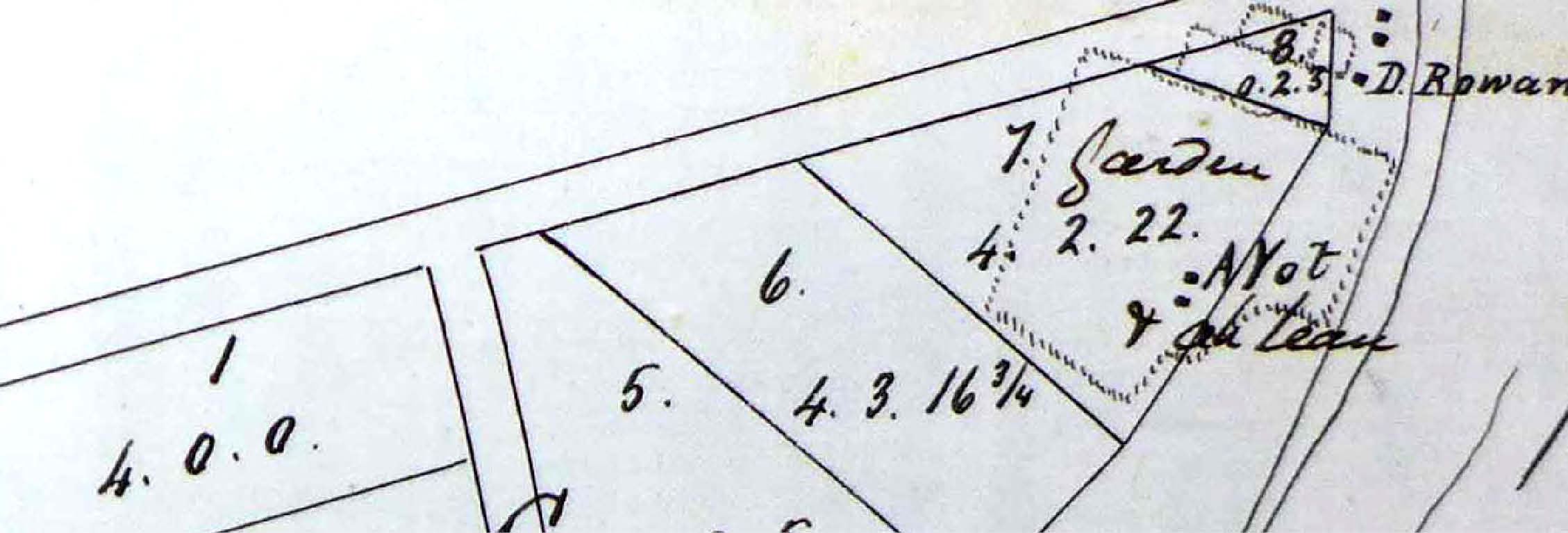
A complex dispute arose the following year over Chinese market gardeners who had earlier established plots on the common by the Loddon River near the township of Bridgewater. Dennis Rowan was by now a manager of the common and wrote in complaint that the Chinese had fenced off 100 feet of land along the riverbank, thus depriving cattle of access to water.[42] Rowan had earlier demanded that one of the Chinese, Ah Yot, attend a meeting and pay £10 for the privilege of cultivating garden plots.[43] However, within the legal context of GFCs, such payments for cultivation purposes were probably illegal.
A petition from six local landholders had also been sent to the managers of the common in July 1863 complaining about the Chinese.[44] It claimed that the Chinese had glut the market with their vegetables, thus depriving European growers of sales and income. Many of the usual objections to Chinese were also rehearsed: they were ‘not good colonists’, hired no labour, failed to build ‘comfortable’ houses in the way of ‘Europeans and other civilised Christians’, and did ‘not marry wives as other men do’. The petitioners’ complaints reveal a mix of racial prejudice and economic jealousy that was typical of goldfields in this period.[45]
In response to such hostility, John Gray wrote to the Board of Land and Works on behalf of Ah Yot, calling attention to the injustice perpetrated on the Chinese (Figure 3).[46] Gray explained that, in early 1861, Ah Yot and his party had fenced ground along the Loddon near Bridgewater for garden purposes. They had supplied Inglewood residents with ‘good and cheap vegetables’ in the years since, including asparagus, cauliflowers, peas and celery.[47] The Chinese were willing to purchase the land or pay a fair rent to the government, allowing for the improvements they had made. Chauncey reported a few days later that Rowan had erected fences and occupied land adjoining the Chinese garden, adding that Rowan’s occupation was as unauthorised as the Chinese party—‘besides which he has a large herd of cattle’. [48] It seems that Rowan wanted the Chinese removed so he could take possession of their land for himself, which was worth ‘at least £100’.

Figure 3: Map showing location of Chinese gardens and Dennis Rowan's property by the Loddon River, PROV, VPRS 242/P0, Unit 246, attached to the letter from John Gray to the Board of Land and Works, 24 October 1864.
Rowan defended himself by pointing out that the Chinese parties of Ah Yot and Ah Yang had fenced-in a total of 10 acres and, thus, no longer held ‘cabbage gardens’ but substantial farms. They employed 24 Chinese hands and used eight horses for carting vegetables a radius of 16 miles. He estimated their receipts at up to £1200 per annum.[49] Rowan’s hostility to the Chinese inadvertently reveals the energy and thrift that brought them agricultural and commercial success. As for the Chinese themselves, they were eager to do the right thing and gain proper legal possession of their land; although, as a consequence of not being naturalised, some form of lease was probably the best they could hope for.
Aboriginal people were also present on GFCs. The Inglewood GFC lay in the traditional lands of the Dja Dja Wurrung people, which extended north from the Great Dividing Range and included the headwaters of the Loddon and Avoca Rivers.[50] Historian Fred Cahir has noted that, despite frequent violent conflict between Indigenous and non-Indigenous people, there was also a high degree of cooperation on the goldfields. Aboriginal people fossicked for gold and worked as police, gold escorts, guides, bark cutters, prostitutes, trackers, child minders, bushrangers, entertainers and prison guards.[51] In May 1865, a group of 12 or so Aboriginal men, ‘accompanied by some lubras and their King with a few picaninnies’, arrived at Inglewood from the Murray River. At night they put on a ‘grand corroboree’—but only after levying money from white onlookers. Aboriginal people were more than capable of exploiting their exotic interest with costume and performance to pursue another angle of economic advantage.[52]
By late 1865, the worst drought then known in Victoria’s European history was beginning to bite.[53] Fees were reduced to help offset the effects of ‘famine and disease’ among stock.[54] Against this background, the Borough Council of Inglewood petitioned the Board of Land and Works to apportion 25,000 acres, fully half of the GFC, as a town common. This was almost 40 square miles and accounted for the better watered eastern half of the common adjacent to the Loddon River (Figure 4). Under the Sale of Crown Lands Act 1860 (Section 69), this meant transferring management of the land away from the distant Maryborough Mining Board, based 60 kilometres to the south, and into the hands of the local council, thereby dramatically increasing the area it controlled. The Inglewood council argued that local management would provide ‘constant and vigilant supervision’ and put an end to the gross mismanagement on the part of the current GFC managers.[55] Counter petitions by miners argued that those who actually used the common were best placed to care for it, and that local ratepayers were entitled to run their stock on the common anyway.[56] This set up an argument between town dwellers and miners that rumbled away for years to come.

Figure 4: Plan of Inglewood Gold Field Common showing area applied for by the Borough Council, marked A, B, C and D, PROV, VPRS 242/P0, Unit 246, plan by District Surveyor Philip Chauncey, 23 October 1866.
The Inglewood GFC was reduced in size to 39,500 acres by the Board of Land and Works on 17 June 1867, when 7,800 acres were transferred to the Inglewood Borough Common.[57] A few years later, there was fear that the neighbouring Korong Shire Council wished to have the remainder of the Inglewood GFC abolished and proclaim a farmers common under their jurisdiction, although no formal application was ever lodged.[58] Over the following years, more of the Inglewood common was taken up by selectors, prompting another petition in July 1874 by several hundred farmers, miners and dairymen asking for an expansion of the common; however, no response is recorded.[59] The Glenalbyn Timber Reserve of 5,580 acres was declared on a temporary basis in September 1874. It was made permanent and excised from the Inglewood GFC in 1887.[60]
By the 1880s, the common had been reduced to a residue of mallee scrub infested with rabbits, the best portions having been selected. A Special Land Board in 1885 heard that 20,000 acres of the remaining common ‘would not keep a cow’, with large areas unable even to grow grass.[61] The Maryborough Mining Board wanted to be rid of the common and the problems it caused. Only a few pounds were available for rabbit control, yet 50 men were needed to do the job properly. There was very little useful land left within the bounds of the common and much of that was littered with treetops left by wood splitters. Cattle numbers were down to 100 or less, meaning small receipts and little money for effective management.[62] The final straw came in 1898 when the Maryborough Mining Board was prosecuted by the Lands Department for failing to destroy all the vermin on the Inglewood GFC. The board simply relinquished control of the common and refused to have any further responsibility for it.[63] Subsequently, the decision was taken to ‘Abolish the common’ and, by June 1898, it had officially ceased to exist.[64]
Most other GFCs were also whittled away by selectors in the nineteenth century and eventually abolished. However, a few endured into the twentieth century, including Lamplough (1861–1931), Omeo (1861–1909), Wedderburn (1861–1941) and Dunolly (1862–1907). The Fryerstown GFC was abolished in 1910 but reinstated in 1927 and lasted for another decade.[65] Although the Inglewood common was gone by the turn of the century, thousands of acres north and west of Inglewood itself were soon reserved as forest for eucalyptus distilling and much remains today as public land in the Inglewood Nature Conservation Reserve and as Crown timber reserves.[66]
Conclusion
The shadow of Garrett Hardin’s ‘tragedy of the commons’ hangs over many discussions of common-pool resources and the history of their use.[67] Hardin argued that common ownership inevitably results in environmental degradation, as each agent (herdsmen in his theoretical example) seeks to maximise his gain at the expense of his fellows. There is no incentive to conserve, and the commons are destroyed as individuals pursue their own interests. Although the model has long been challenged by economists, historians, sociologists and others, it is still important to ask how the commons functioned in specific historical circumstances.[68] The commons provided a middle or third way of land management between exclusive state control and complete private ownership.
In the English tradition of common lands, a productive commons had always been an insurance against hard times, a retreat when survival was threatened. The commons provided fuel, food and materials that gave people a degree of independence and freedom from the marketplace for labour and goods.[69] However, the enclosure movement deprived commoners of access to land and turned them into landless labourers, paupers or emigrants to the New World and Australasia. Conversely, GFCs in Victoria were less a refuge than a resource to be exploited. People paid fees to graze dairy cows, horses and sheep but they were always subject to a range of controls and oversight. Local herdsmen and managers had responsibility for day-to-day management, while district mining boards created rules and regulations and the more distant but powerful Board of Land and Works had the power to change the boundaries and status of the commons. Time and use brought growing awareness of the potential and limits of the commons’ natural resources. The Inglewood GFC was not necessarily ruined or destroyed; however, it was diminished as selectors claimed the best parts, leaving the scrubby remainder to be overrun with rabbits and reclassified as a timber reserve. There was no ‘tragedy of the commons’; instead, there was a rough balance of competing interests.
The Inglewood GFC was a large, useful—but also troublesome—public domain for local people. As such, it was a contested space, a locus of competition, jealousy, conflict and, on occasions, racism. There were accusations of greed, corruption, mismanagement and negligence. Petitions were met with counter petitions as people sought favourable consideration and preferment from local, regional and colonial officials. The commons kept potentially auriferous land in public hands and allowed gold prospecting to continue. It may also have provided a place for fringe dwellers to eke out a living in remote corners of the goldfields.[70] As miners abandoned the goldfields and made their lives elsewhere, most of the common land they left behind was too poor and degraded for farming. Much of it remained as Crown land and persists today in public ownership.
Endnotes
[1] JC Weaver, The great land rush and the making of the modern world 1650–1900, McGill-Queen’s University Press, Montreal, 2003.
[2] JM Powell, The public lands of Australia Felix: settlement and land appraisal in Victoria 1834–1891 with special reference to the western plains, Oxford University Press, Melbourne, 1970, p.80.
[3] Powell, The public lands of Australia Felix, pp. 80–83.
[4] R Wright, The bureaucrats’ domain: space and the public interest in Victoria, 1836–1884, Oxford University Press, Melbourne, 1989, p. 6.
[5] Ibid., pp. 5–7.
[6] JM Neeson, Commoners: common right, enclosure and social change in England, 1700–1820, Cambridge University Press, Cambridge, 1993, pp. 41–42.
[7] WE Colby, ‘The freedom of the miner and its influence on water law’, in M Radin & AM Kidd (eds), Legal essays in tribute to Orrin Kip McMurray, University of California Press, Berkeley, 1935, p. 69.
[8] Neeson, Commoners.
[9] EP Thompson, The making of the English working class, Random House, New York, 1964, p. 218.
[10] WG Hoskins & LD Stamp, The common lands of England and Wales, Collins, London, 1963, p. 3.
[11] M Bowden, G Brown & N Smith, An archaeology of town commons in England, English Heritage, Swindon, 2009.
[12] B Maddison, ‘Radical commons discourse and the challenges of colonialism’, Radical History Review, vol. 108, 2010, pp. 29–48; Wright, The bureaucrats’ domain, p. 6.
[13] BH Fletcher, Landed enterprise and penal society: a history of farming and grazing in New South Wales before 1821, Sydney University Press, Sydney, 1976, p. 46.
[14] F Watson (ed.), Historical records of Australia. Series I, Governors’ despatches to and from England, vol. 7 (January 1809 – June 1813), The Library Committee of the Commonwealth Parliament, Melbourne, 1916, p. 400.
[15] ‘Report of the Commission appointed to enquire into the tenure of the waste lands of the crown’, Victorian Parliamentary Papers, B–no. 70, 1854–1855. p. 63.
[16] ‘Report of the Commission appointed to enquire into the conditions of the gold fields of Victoria’, Victorian Parliamentary Papers, A–no. 76, 1854–1855. p. xiv.
[17] Powell, The public lands of Australia Felix, p. 66.
[18] D Goodman, Gold seeking: Victoria and California in the 1850s, Allen & Unwin, Sydney, 1994; S Lawrence, Dolly’s Creek: an archaeology of a Victorian goldfields community, Melbourne University Press, Melbourne, 2000.
[19] ‘Report of the Commission appointed to enquire into the conditions of the gold fields’, pp. xiv–xix; C Wright, The forgotten rebels of Eureka, Text, Melbourne, 2013, pp. 208–210.
[20] T Dingle, The Victorians: settling, Fairfax, Syme & Weldon Associates, Sydney, 1984, pp. 58–76; Powell, The public lands of Australia Felix; JM Powell (ed.), Yeoman and bureaucrats: the Victorian Crown Lands Commission 1878–1879, Oxford University Press, Melbourne, 1973.
[21] JH Brooke, ‘Regulations for farmers’ commons’, Victorian Parliamentary Papers, no. 69, 1860–1861.
[22] C Hodgkinson, ‘Commons. Reply to question put by Mr. K. E. Brodribb’, Victorian Parliamentary Papers, A–no. 28, 1862.
[23] JH Brooke, ‘Gold Fields Commons. Proclamation’, Victorian Parliamentary Papers, no. 59, 1861; Lawrence, Dolly’s Creek, pp. 94–95.
[24] P Nelson & L Alves, Lands guide: a guide to finding records of Crown land at Public Record Office Victoria, Public Record Office Victoria, Melbourne, 2009, p. 197.
[25] ‘Residence and cultivation licenses’, Victorian Parliamentary Papers, A–no. 9, 1861.
[26] E Nathan, Lost waters: a history of a troubled catchment, Melbourne University Press, Melbourne, 2007, pp. 21–22.
[27] C Hodgkinson, ‘Commons. Reply to a question put by Mr. K. E. Brodribb’, Victorian Parliamentary Papers, A–no. 28, 1862.
[28] Victoria, Mining surveyors’ reports, vol. 35 (February 1861), Dave Evans, Ballarat, p. 67; Select Committee, ‘Report from the Select Committee on Mr. Hines’s case’, Victorian Parliamentary Papers, D–no. 38, 1861–1861. Commonage was also available on the New Zealand goldfields but much more sparingly so than in Victoria. Goldfields officials and ‘wool lords’ colluded to minimise diggers’ access to grazing land. See S Eldred-Grigg, Diggers, hatters & whores: the story of the New Zealand gold rushes, Random House New Zealand, Auckland, 2008, pp. 344–346.
[29] Hodgkinson, ‘Commons’, pp. 4–6.
[30] Bureau of Meteorology, climate data online, station 810020, available at <http://www.bom.gov.au/climate/data/>, accessed 4 April 2017.
[31] Environment Conservation Council, Box-Ironbark forests and woodlands investigation resources and issues report, Environment Conservation Council, Melbourne, 1997.
[32] J Flett, The history of gold discovery in Victoria, The Hawthorn Press, Melbourne, 1970, p. 302.
[33] D Bannear, Historic mining sites in the Inglewood, Wedderburn and St Arnaud mining divisions, Department of Conservation and Natural Resources, North West Area, [Bendigo], 1994, p. 7; AM Nixon, Inglewood gold, rev. edn, Sundowner Press, Greensborough, 1982, p. 16.
[34] Bannear, Historic mining sites, pp. 5–19; K Twigg, ‘City in the scrub’: Inglewood conservation study, Masters thesis, Monash University, 1989, pp. 1–2.
[35] Victoria Government Gazette, no. 18, 6 February 1861, p. 259.
[36] PROV, VA 538 Department of Crown Lands and Survey, VPRS 242/P/0 Crown Reserves Correspondence, Unit 246, memo from Philip Chauncey, 8 October 1862.
[37] PROV, VPRS 242/P0, Unit 246, letter from Dennis Rowan to president, Board of Land and Works, 23 February 1861.
[38] PROV, VPRS 242/P0, Unit 246, letter from Dennis Catto to Philip Chauncey, 3 March 1861.
[39] W Owen, Map of Victoria including the pastoral runs with alterations to 1868, Melbourne, [1968] State Library of Victoria, available at <http://search.slv.vic.gov.au/MAIN:Everything:SLV_VOYAGER659153>, accessed 9 May 2018; P de Serville, Pounds and pedigrees: the upper class in Victoria 1850–80, Oxford University Press, Melbourne, 1991, p.381; C Webb & J Quinlan, Greater than gold: a history of agriculture in the Bendigo district from 1835 to 1985, Cambridge Press, Bendigo, 1985, pp. 72–73.
[40] PROV, VPRS 242/P0, Unit 246, letter from Philip Chauncey to Mining Board Office, Maryborough, 18 September 1862.
[41] PROV, VPRS 242/P0, Unit 246, letter from James Granger to president, Board of Land and Works, 18 June 1863; ‘Inglewood Goldfield Common’, Inglewood Advertiser, 28 January 1863.
[42] PROV, VPRS 242/P0, Unit 246, letter from Dennis Rowan, report of the managers of the Inglewood Goldfield Common, 23 May 1864.
[43] PROV, VPRS 242/P0, Unit 246, letter from Dennis Rowan to Ah Yot and party, 8 April 1864.
[44] PROV, VPRS 242/P0, Unit 246, petition to the managers of the Inglewood Gold Field Common, 1 July 1863.
[45] K Cronin, Colonial casualties: Chinese in early Victoria, Melbourne University Press, Melbourne, 1982, pp. 41–79; A Markus, Fear and hatred: purifying Australia and California 1850–1901, Hale & Iremonger, Sydney, 1979, pp. 34–43; Twigg, ‘City in the scrub’, p. 52
[46] PROV, VPRS 242/P0, Unit 246, letter from John Gray to president, Board of Land and Works, 24 October 1864.
[47] ‘Chinese gardens’, Maryborough and Dunolly Advertiser, 3 July 1863, 6f.
[48] PROV, VPRS 242/P0, Unit 246, letter Philip Chauncey to president, Board of Land and Works, 28 October 1864.
[49] PROV, VPRS 242/P0, Unit 246, letter from managers of Inglewood Common to Board of Land and Works, 15 November 1864.
[50] ID Clark, Aboriginal languages and clans: an historical atlas of western and central Victoria, 1800–1900, Monash Publications in Geography No.37, Monash University, Clayton, 1990, p. 153.
[51] F Cahir, 2012, Black gold: Aboriginal people on the goldfields of Victoria, 1850–1870, Aboriginal History and ANU EPress, Canberra.
[52] Cahir, Black gold, p. 80.
[53] D Garden, Droughts, floods & cyclones: El Niños that shaped our colonial past, Australian Scholarly Publishing, Melbourne, 2009, pp. 45–55; J Keating, The drought walked through: A history of water shortage in Victoria, Department of Water Resources Victoria, Melbourne, 1992, pp. 33–38.
[54] PROV, VPRS 242/P0, Unit 246, petition of about 175 people to president and members of the Board of Lands and Survey, 26 October 1865.
[55] PROV, VPRS 242/P0, Unit 246, petition, Alex McNaughton, Inglewood town clerk, to Board of Land and Works, 12 December 1865.
[56] PROV, VPRS 242/P0, Unit 246, petition from farmers, dairymen and owners of stock depasturing on the Inglewood Goldfield Common to Board of Land and Survey, c.1866.
[57] PROV, VPRS 242/P0, Unit 246, Office of Lands and Survey, internal note, 17 June 1867; PROV, VA 538 Department of Crown Lands and Survey, VPRS 8769/P1 Register of Description of Permanent Reserves-Commons, Unit 1, p. 111; Victoria Government Gazette, no. 70, 25 June 1867, p. 1137.
[58] PROV, VPRS 242/P0, Unit 246, petition of 13 miners to the Maryborough Mining Board, March 1870.
[59] PROV, VPRS 242/P0, Unit 246, petition to the minister of lands, 21 July 1874.
[60] Victoria Government Gazette, no. 53, 17 June 1887, p. 1852.
[61] ‘Meeting of a Special Land Board’, Inglewood Advertiser, 6 August 1885, 2e.
[62] PROV, VPRS 242/P0, Unit 246, letters from David Beckett, clerk of Maryborough Mining Board, to secretary for lands, 15 March 1887 and 21 December 1887.
[63] PROV, VPRS 242/P0, Unit 246, letter from K Guy, clerk of Maryborough Mining Board to secretary for lands, 9 February 1898.
[64] PROV, VPRS 242/P0, Unit 246, Lands Department memo, 11 March 1898; Victoria Government Gazette, no. 51, 3 June 1898, p. 1954.
[65] Victoria Government Gazette, no.172, 14 December 1927, p. 3930.
[66] Twigg, ‘City in the scrub’, p. 79.
[67] G Hardin, ‘The tragedy of the commons’, Science, vol. 162, no. 3859, 1968, pp. 1243–1248.
[68] See, for example, E Ostrom, Governing the commons: the evolution of institutions for collective action, Cambridge University Press, Cambridge, UK, 1990; D Wall, The commons in history: culture, conflict and ecology, The MIT Press, Cambridge, MA, 2014.
[69] Neeson, Commoners, p. 177.
[70] See correspondence of forester John La Gerche and his dealing with prospectors on the Creswick goldfields in the 1880s and 1890s, in A Taylor, A forester’s log, Melbourne University Press, Melbourne, 1998.
Material in the Public Record Office Victoria archival collection contains words and descriptions that reflect attitudes and government policies at different times which may be insensitive and upsetting
Aboriginal and Torres Strait Islander Peoples should be aware the collection and website may contain images, voices and names of deceased persons.
PROV provides advice to researchers wishing to access, publish or re-use records about Aboriginal Peoples