Last updated:
Refereed articles
City views
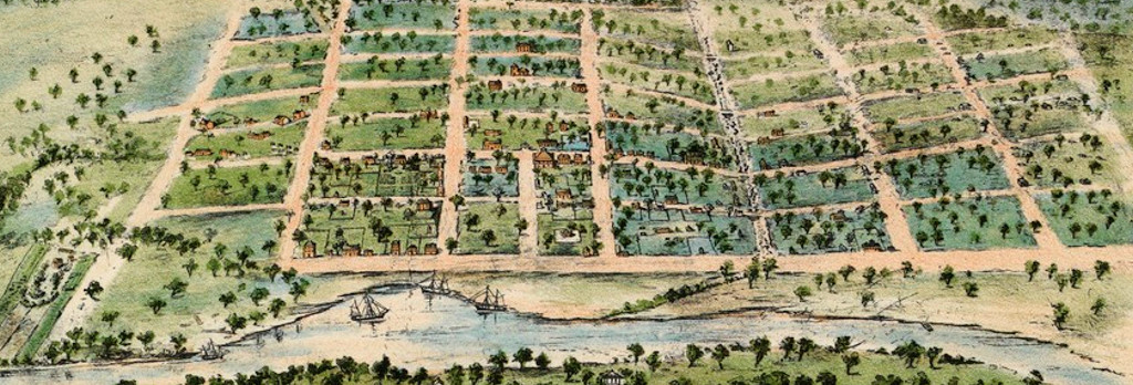
modelling Melbourne at the Royal Exhibition Building
Expand SummaryThis article examines the history of the construction of a scale model of Melbourne in 1838 that was made in 1888 for the Centennial International Exhibition, (Royal) Exhibition Building, Melbourne, and its reinterpretation in Clarence Woodhouse’s lithograph Melbourne in 1888, from the Yarra Yarra, often erroneously cited as having been created in 1838. Reception of the model reveals that it held, at times, contradictory meanings for a variety of audiences and was a touchstone for nostalgic reflections about Melbourne’s past, the progressive achievements observable in its present and uncertainties about urban development in its future. With the opening to the public of the Royal Exhibition Building’s dome promenade in 2022, Melburnians can again reflect on a novel city view, note the pace of urban change, and debate the balance between future development and maintaining, through view protection, the Outstanding Universal Value of the World Heritage listed building.
The value of rate books and multi-scale analysis
a Hotham/North Melbourne case study
Expand SummaryImagine there was a document from nineteenth-century Victoria that could tell you where a person lived and what their house was like, whether they owned it or rented, how big it was, what it was made of and what their occupation was? And what if that document could also tell you all that information about all of their neighbours? And the whole local government area? What if that same archive could tell you what percentage of people in an area rented their properties in one year, and how that changed over the course of a decade, and several decades, including a breakdown of ownership by occupational status? Such an archive does exist: the rate books held by Public Record Office Victoria. This paper explains what rate books are and how they offer multi-scale analysis—the ability to zoom in and out at micro and macro levels. The use of rate books by professional historians to quantify data as evidence of the material development of a local area has received little attention for several decades. This method of analysis can and should be revived. Using samples of evidence from a study of the nineteenth-century rate books for Hotham/North Melbourne, this paper reveals the remarkable details about the development of housing ownership patterns these archives can provide.
Land, water and property
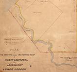
surveying the Boort pre-emptive right
Expand SummarySurveyors in colonial Victoria were responsible for turning land into property. The maps and plans they created imposed geometric patterns on landscapes that represented white ownership and control and the appropriation of Indigenous land. Under the 1847 Orders in Council, squatters could apply for survey and purchase of a pre-emptive freehold of at least 160 acres, giving them security over their homesteads, yards and other pastoral ‘improvements’. Control of water was a vital part of this process, especially on the dry plains of northern Victoria. Pre-emptive rights typically secured access to reliable water in creeks or rivers, but the law forbade control of dual water frontages to prevent undue monopoly of water supplies. The ‘Frederick Byerley Case’ provides important insight into the determination of land, water and property boundaries in colonial Australia, and how surveyors negotiated the conflict between private rights and the public interest. In 1857, Frederick Byerley surveyed a pre-emptive freehold at Boort Station on the lower Loddon floodplain. His plan included both sides of the highly ephemeral Kinypanial Creek to incorporate a small weir the station-owners had constructed to capture and hold more water in the creek channel. This inclusion was later deemed unlawful and led to Byerley losing his job in the Survey Department. He protested his dismissal, and a parliamentary select committee was commissioned in 1858 to decide on the case. The case hinged on whether the terminus of the creek was still in its natural state and thus subject to the regulations that prohibited monopolies of double frontages, or if the weir had created an artificial water storage or pond, in which case the regulations would not apply and Byerley’s dismissal was in error. The case highlights the complexities of applying imported English laws to topographic features that confounded colonists’ implicit assumptions about the permanence of water.
Forum articles
Tracing ancestral voices
Expand Summary
‘Tracing ancestral voices’ outlines a genealogical research journey involving memory, emotion, history and archival research. It demonstrates the reclamation of lost ancestors and their stories, covering the inevitable highs and lows of archival research. Resources employed during this research include the archives, databases and websites of Public Record Office Victoria, Birth Deaths and Marriages Victoria, the Department of Health and Human Services, and other government resources.
At the centre of this research are the author’s grandfather, Charles William Stott/Hicks, and great-grandmother, Ethel Blanche Hicks. Just days before passing away in 2008, Charles had whispered into the ear of his great-grandson: ‘You can’t choose your family.’ Those curious words were the inspiration for the author’s family history inquiries. The research started with birth and death certificates, eventually leading to state ward records. These revealed that, in 1924, Charles, aged five, and his siblings, had been made wards of the state of Victoria. To understand possible causes for this, numerous public document collections and institutional records were analysed and cross-referenced to show how details and discrepancies can be used to support hypotheses and speculation.
Reader warning: the terms ‘mentally deficient’ and ‘illegitimate’, which some may find offensive, are used in some of the records. They are used here to offer insight into the historical context of the era.
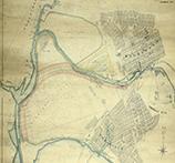
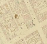
Reshaping the Yarra
unrealised plans and visions for the Port of Melbourne
Expand SummaryGovernment archives, like those held at Public Record Office Victoria (PROV), provide documentary sources that allow us to visualise changes to natural and built environments over time. Using maps and plans from PROV’s collection, this article explores plans and decisions associated with the Yarra River and the developing Port of Melbourne from the 1850s to 1973. The article explores changes to the course of the river and the surrounding area, as well as proposals for changes that were never implemented.
Antonio Azzopardi, Australia’s first Maltese immigrant
an exploration of his life and sources of information
Expand SummaryDuring 2023, I collaborated with the National Archives of Australia (NAA) to find records within Public Record Office Victoria (PROV) for an NAA function and display celebrating the seventy-fifth anniversary of the signing of the immigration agreement between Australia and Malta. The function took place at the Victorian Archives Centre on 6 May 2023 and the exhibition, titled ‘From restricted to assisted. Minn Ristrett ghal Assistit. Maltese migration to Australia’, included records I located relating to Antonio Azzopardi, an early European settler at Port Phillip. Starting with a variety of publicly available resources, I then located a range of public records within the PROV collection that assisted in telling part of Azzopardi’s story, most of which could not be included within the exhibition. This paper combines the public records I located with non-government records and secondary sources to produce a sketch of Azzopardi’s life in Victoria and outline his achievements. Although not the main focus, the article also reveals in passing some of the difficulties that occurred in using some of the publicly available resources, as starting points for this research, and some of the public records, and the extent to which various claims made about Antonio’s life could (and could not) be substantiated.
‘Wayward’, ‘immoral’ and ‘evil’
dispelling myths about Brookside Reformatory girls
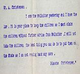
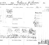
Expand SummaryBetween 1887 and 1903, 257 girls were sent to the Brookside Reformatory, Victoria’s first privately run Protestant reformatory for girls. However, apart from newspaper articles and parliamentary reports that mostly shamed the girls and called them ‘wayward’ and ‘evil’, little is known about their lives. Using documents from Public Record Office Victoria and material from the State Library of Victoria and Trove, this article seeks to challenge assumptions about the Brookside girls by examining the lives of two inmates, Jessie Nairn and, to a lesser extent, Selina Wilson. After spending four years at Brookside, Jessie Nairn got married and had children and, by all accounts, was a loving mother. Other girls are mentioned to show their socio-economic circumstances and the cruel societal assumptions about them. This work is ongoing as I attempt to locate more records about the girls to challenge stereotypes and reinstate their dignity.
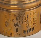
Victoria’s system of weights and measures administration
Expand Summary
Victoria became a separate colony of the United Kingdom on 1 July 1851; however, it took until 1864 for a workable system of weights and measures administration to be introduced. Standard of weights and measures were obtained and issued to local authorities to administer in their local areas. These standards were numbered, as were the Crown stamps used by inspectors to indicate that trade weights and measures had been checked and found to be legal to use in the day-to-day businesses of local traders. The registers of issued weights and measures, as well as general weights and measures records for different periods, held by Public Record Office Victoria are highlighted in this article. Examples of how the numbers can assist in identifying where the weights and measures were used in Victoria between 1864 and the 1990 are provided. As far as the author is aware, the history and use of this numbering system has gone unnoticed or ignored by other researchers, but he would be delighted to be shown to be incorrect.
Material in the Public Record Office Victoria archival collection contains words and descriptions that reflect attitudes and government policies at different times which may be insensitive and upsetting
Aboriginal and Torres Strait Islander Peoples should be aware the collection and website may contain images, voices and names of deceased persons.
PROV provides advice to researchers wishing to access, publish or re-use records about Aboriginal Peoples